Logan, Utah

July 17, 2016 by

Sunday, 17 July 2016

IMG_2154

Above, our home from home in Boise, an apartment above a garage, a shady yard well suited for a brew. A good experience.

It was about 8 by the time we rolled out of Boise. Freeway speed limit is 80 here, which is about as much as this little Kia Soul is comfortable with. Some dry desert country, but a lot of really pretty scenery along the Snake River valley. Irrigation monsters everywhere. UPDATE: Wind was the problem. On a subsequent day without gusty cross-winds, the car was just fine at 80.

IMG_2158

We have no desire for marathon days on the road; 250 or 300 miles is plenty long enough, thank you. We didn’t really stop until we reached Tremonton, whose one claim to fame, I guess, is the mural above. We wandered a few minutes, got back in the car and came on to Logan, a pleasant town we visited before under quite different circumstances.

Left the car and walked some more. Sunday is not the day to come to Utah; lots of things closed, pretty much no one on the streets.

IMG_2159

I’m not really up on my religious mythology, but I think Zion may not mean the same thing to Mormons as it does to Jews. But don’t quote me.

IMG_2164

A Mormon town, though, and no mistake. This is the tabernacle.

IMG_2172

And standing on a hill above the town, this is the temple. What’s the difference, you ask? And so did we. Well, there are very few tabernacles; apparently they are no longer being constructed or consecrated, but the great unwashed are welcome in tabernacles. Temples are only open to those who follow the Way. No idea whether there is a certification of some kind that you need to produce to get past the temple gates.

IMG_2185

Missionary attire? That kind of town. Not a lot of graffiti here, as you might expect.

IMG_2160

Otherwise, it’s a nice enough little place, or would be if everything were open, if the sidewalks were crowded with people making their way past those sitting at sidewalk tables enjoying the day.

IMG_2181

One thing you can say about Mormons: they are not big on poverty. And good for them.

IMG_2179

For those who are old enough to understand this, it’s highly apropos!

We discovered that my smartphone is prepared to give voice directions to navigate via GPS (most places I go, I don’t need directions, so never had occasion to find out!). Very handy; thank you Mr Android and Mr Samsung and Mr whoever.

From the B&B, we wandered out again, looking for something to eat. The fast-food places are open; there’s Denny’s and Sizzler and … and we ended up at The Old Bull (El Toro Viejo) for more Mex than we could have eaten in two days. Pretty good.

Boise

July 16, 2016 by

Saturday, 16 July 2016

Boise lies in the flat country just west of the mountains. A little online exploration reveals that there are no end of trails nearby, most of them in the mountains. The Table Rock loop sorted to the top of the list, and seems to be pretty interesting, so that’s where we went today. Parking at the old Penitentiary.

Which reminds me … what a misnomer that is! Had this truly been a home for penitents, it would not have needed guards or locks. It might have been called a monastery. The current equivalent is correctional institute, equally a misnomer.

IMG_1939

There were no paper maps, but the kiosk at the trailhead showed the options. Pretty simple; we took trail 15A up, went around the hill on 16, and came back down 15.

IMG_1940

There was a volunteer crew busy uprooting weeds. I thanked them for the effort. Always makes me feel good when I’m in their shoes and someone thanks me.

IMG_1957

The whole area burned recently. Long enough ago that it only weakly smells of smoke, but not very attractive.

IMG_1955

It was great to see the vegetation beginning to come back. For example, this green grass shooting out from the lump of burned grass.

IMG_1963

IMG_2013

The photo above came from the non-burned area, just to show what the single orphan flower further up will look like if it has a chance to mature.

IMG_1968

IMG_1965

Once we finally topped out and had a wide view further east, we could see the extent of the burn area, looking for all the world like cloud shadow.

IMG_1971

It’s called table rock because it was once the sedimentary solid floor of a lake, now elevated a couple thousand feet above the surroundings.

Up here at the top, a man with a dog. The dog running around, full of energy, full of life, full of joy. It had three legs.

IMG_1980

IMG_2009

There are communications antennas up here, consequently a road. But only a few cars; most people walked up and back down.

IMG_2001

IMG_2005

One of the bikies was a woman, who walked most of the way down, not confident in her brakes. The other bikie was a guy who rode the whole way. Not far from the bottom, and just ahead of us, he hit a rock the wrong way and took a spectacular fall. Not hurt beyond the usual scrapes, which is good.

IMG_2015

We found a shady picnic table outside the walls of the old penitentiary and enjoyed the views of the warden’s house and the bishop’s house while we munched our apples. Didn’t sign up for the penitentiary tour itself; we’d rather spend the time at the botanical garden.

IMG_2053

And so we did. It’s just outside the penitentiary walls itself, so we saw some of the outside.

IMG_2056

IMG_2081

I loosed off a raft of shots at this dragonfly, and am delighted that a couple of them turned out well. They clearly show that the leading edges of the wings are open.

IMG_2150

IMG_2096

Well, the botanical garden was very much worth the time, and I have a boatload of photos. But I won’t bore you with more than just a few.

IMG_2116

IMG_2036

IMG_2125

IMG_2129

There was a little creek, possibly with pumped recirculating water, covered with water striders. Cool!

IMG_2131

Back to the B&B for naps, then laundry, then a cool beer in the back yard, then to a middle eastern restaurant for goodies.

Nice day. Tomorrow, Logan, Utah.

Boise

July 15, 2016 by

Friday, 15 July 2016

Almost every business in Nevada has some kind of gambling. The motel restaurant was on the far side of the casino. Breakfast was good and  very inexpensive; they figure the Scylla-Charybdis ordeal of the slot machines will make up the difference. Not for us, but thank you for the exceptional food value, anyway.

We took highway 95 north out of Winnemucca, a road that runs absolutely straight as far as the eye can see, until it needs to go over the low pass between a pair of mountain ranges. Then it jogs a little, comes down the other side and makes a beeline for the next pass. If the phrase basin and range didn’t already exist to describe this country, it would have to be invented.

Deadly dull, most of it. Sagebrush. Further north, we get into the volcanic lava flow, presumably from the Yellowstone caldera, which is phenomenally ugly where it is exposed at the surface.

Eventually, we got to the junction with highway 78 in Oregon, and turned east. Almost immediately the country got better. There is still a thin layer of hard volcanic capstone, but it has collapsed in many places, exposing sedimentary underlayers that have eroded into pretty formations.

IMG_1841

These are called the Roman columns, naturally located at Rome, Oregon.

But the pretty sedimentary formations don’t last long, either, and we’re back to dreary scrub desert. Better as we approached the Snake river, at Marsing, where we pulled off for a very welcome look at water, grass, trees. Wonderful!

IMG_1842

IMG_1864

IMG_1878

IMG_1876

Suitably refreshed, we went on into Boise. It was only within the last ten years or so that I realized what the name of this town really is; having lost the accent off the trailing e, and anglicized its pronunciation, it was not as obvious as it certainly ought to have been. Better late than never: now we often pronounce it the French way, just for grins.

Found our airBnB without a whole lot of trouble. Our hostess is away at the Grands Tetons today, so we’ll meet her tomorrow. No worries; we dropped off our things and went out to explore.

IMG_1895

IMG_1899

IMG_1902

IMG_1911

IMG_1916

IMG_1924

IMG_1929

IMG_1933

Found the Double Tap pub, where I enjoyed a Moose Drool and Jacky found a porter that she liked.

IMG_1910

Then we walked back over to this building, which houses an Indian restaurant. Spoiled again.

On the way back to the BnB, we stopped at an Albertson’s grocery — turns out to be the same site as the first supermarket opened by Mr Albertson in 1939 — and bought breakfast fixings. Saves us some money and will be healthier and very likely better too.

Big Trees and Ebbetts Pass

July 14, 2016 by

Thursday, 14 July 2016

Big breakfast at Hillbillies restaurant, Murphys. Then we headed on up highway 4. First stop, Calaveras Big Trees state park.

IMG_1702

We have been here before, of course, but not for a long time. Pretty classy.

IMG_1710

IMG_1712

IMG_1727

IMG_1738

IMG_1747

IMG_1751

IMG_1766

Not everything here is gigantic. By the way, the understory is mostly dogwood. We need to come back here some time when it’s in full bloom; it must be spectacular.

IMG_1773

IMG_1774

IMG_1779

IMG_1783

IMG_1785

Cyclists heading uphill, most likely training for the Markleeville Death Ride. Good to see them out. The road is wide and good as far as the ski areas, then becomes challenging. Good pavement, but too narrow for a center line, sharp, blind curves, steep grades. We stopped several times for scenery breaks, but were happy when we bottomed out along the east fork Carson river going into Markleeville.

IMG_1795

IMG_1801

IMG_1817

IMG_1821

IMG_1835

IMG_1837

From the junction with highway 88 north of Markleeville, we took the same route that we rode on our trans-continental bicycle tour, through Fallon and then to Winnemucca. Found a motel and dumped our stuff.

Very hot day, but of course we went out looking for a brew and a meal. Maps on our smartphones are not very helpful, but we did find a cool quiet place for a couple of beers — then saw another couple places later on. We decided on Martin’s Hotel, a basque restaurant. You order your own entree, but the rest is family style. We shared a long table with a couple from Hanford Ca, and three from near Tampa. Good food, nice to talk with some new people.

The Mother Lode

July 13, 2016 by

Wednesday, 13 July 2016

We’re off! Also, we got started on a vacation trip to Nebraska. Go figure! (Maybe that proves that we’re off.) I just signed up with AirBnB, and our first experience will be tonight in Murphys. The software is a bit flaky, but we hope the room isn’t.

IMG_1433

First sight to see was the wizard of Oakdale. And we know nothing more than what you see right here, so don’t ask.

IMG_1451

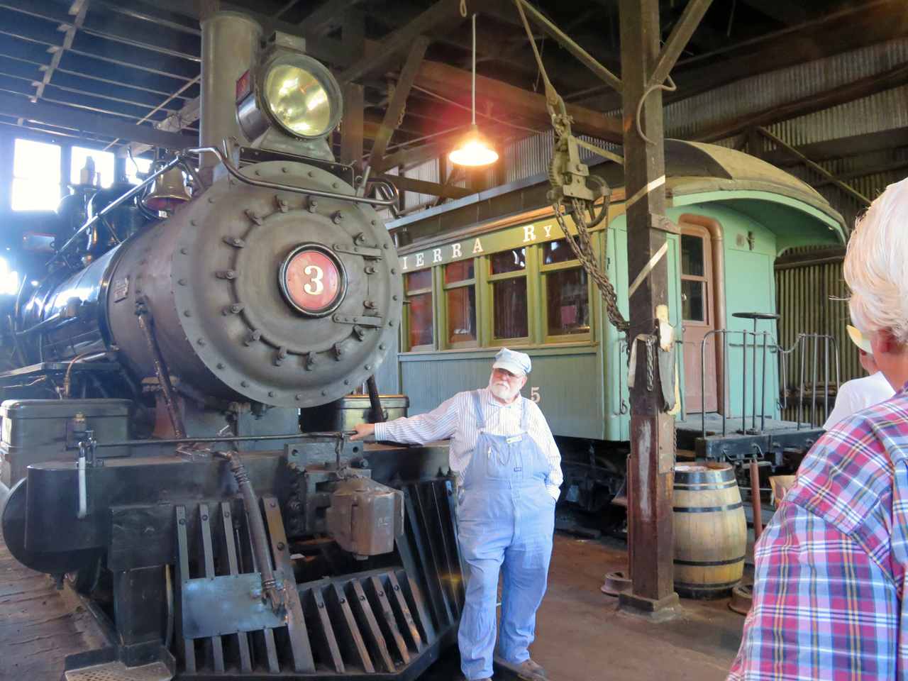
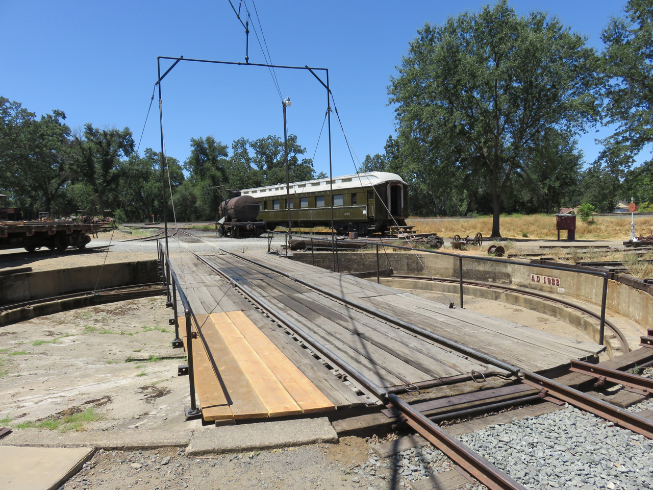
The water tower from Petticoat Junction. In fact, we are at Railtown, the museum at Jamestown. We’ve been here before, but not for quite a number of years, so it’s nearly new. We aren’t much interested in train rides, especially behind today’s Diesel offering, but of course signed up for the guided tour of the roundhouse.

IMG_1464

IMG_1480

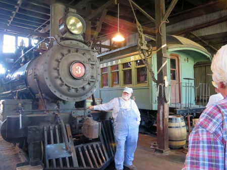
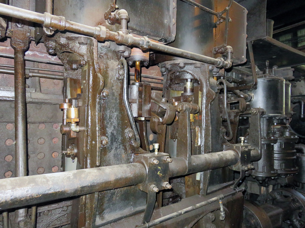
Of course, Shays are the most interesting Loks of all, because you can see all the gubbins doing their gubbing. Also because they are the real workhorses of rough country, grades, agility, anything you want, except speed. Max is about 15 mph, with a brave engineer. Our guide says they shed parts; whenever they take this one out for a run, they have a patrol to sweep the route afterward to collect the bits and pieces that get left behind. Great toys!

IMG_1493

IMG_1494

IMG_1501

One of the guys on the tour was a volunteer at another rail museum, and was kind enough to explain the speed and reversing mechanism in terms that pretty much most of us could understand. I even mostly understood it myself.

IMG_1507

This was another interesting artifact. It’s called a blind driver, a drive wheel without a flange. It rides between fore and aft flanged wheels, and cannot have a flange itself because it has to mediate between its neighbors on curves. I don’t think I knew about these before.

IMG_1513

The wheels themselves are cast iron, too soft and brittle to stand up to the load, so they have tires. Above, a tire ring, a loop of gas jets that heats the tire red hot, which causes it to expand enough that it can be slipped over a cast iron base wheel. The tire can be machined down a few times as it wears, and is eventually replaced with another. Replacing a tire was a good job to complete just at quitting time, so things would be cool enough to work with come next morning.

IMG_1517

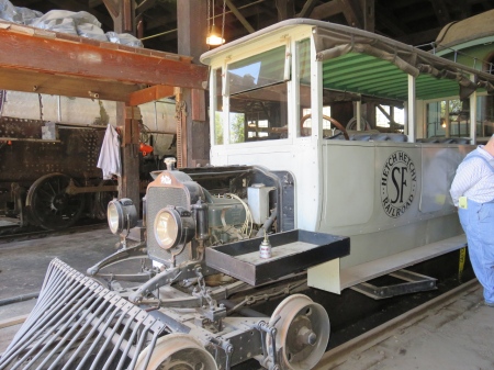
To ferry VIPs to the Hetch Hetchy dam construction site, this White truck was turned into a rail vehicle. A couple of interesting things: behind the cowcatcher and between the leaf springs is the crank start. That must have been tricky.

The steering wheel remains in place, because the throttle and such were mounted on the steering column. So they adapted the wheel to apply the front brakes.

But most interesting of all is the square frame visible midships below the vehicle. It could be put down onto the rails. The vehicle was jacked up so that the wheels cleared the rails, and spun around to go back the other direction. A built-in turntable!

IMG_1549

As well as bits and pieces for the Loks, they made tools here. A complete machine shop, and with overhead shaft power. Unfortunately, the buildings have shifted to be out of true, so the shafts cannot safely be run today.

IMG_1548

Some of the pulleys are wooden laminates.

IMG_1554

The roundhouse was round, of course, because it at least partially surrounded a turntable.

IMG_1560

The turntable is (now) driven by compressed air.

It wasn’t so hard to turn the table, but stopping a swinging Lok required finesse as well as brute force.

IMG_1563

I liked the little locking slider here.

IMG_1577

These artifacts have a long and colourful history in the movies. Several of the Loks and cars are half length, which was convenient on tight mountain turns, but also in wide-angle views of trains in western movies, where pretty much no one ever notices.

IMG_1578

Smokestack cosmetics, to make the Loks look like whatever they wanted. By the way, westerns typically show the tenders piled high with firewood, but wood hasn’t been used for two hundred years. All of these Loks burn oil, even during their stints in the movies.

IMG_1585

The freight room; I especially like the good-sized crate containing an Underwood typewriter.

Enough! We went on to Columbia, a state historic park. Real gold rush history here, a place where the placer washes undermined the houses of the town; not a problem, houses can be rebuilt.

IMG_1594

Popular and picturesque place.

IMG_1606

We saw serious industrial blacksmithing this morning. Here’s the other side of the coin, the smith busy at work making ornamental horseshoes and other tourist merchandise.

IMG_1611

IMG_1615

Time for lunch, enough that we really weren’t hungry this evening.

IMG_1638

A real Wells-Fargo office. Their scale was accurate enough to weigh the signature in pencil on a piece of paper.

IMG_1647

And real horses. Not sure how much of the rest is real, but it’s a good time for all.

IMG_1648

And panning for gold is probably a good lesson in how dirty, thankless and unprofitable most miners discovered their lives to be.

Enough! Time to go to Murphys. Parrot’s Ferry road is a good route. I had this road in mind some years ago when I took Wards Ferry road into Sonora from the south. The worst drive I ever had in my life. Steep grades, vertical on both sides, less than one lane wide in many places. Well, today was much better.

IMG_1660

IMG_1662

IMG_1666

Murphys’ unique claim to fame is its E Clampus Vitus wall of comparative ovations. Sometimes humorous, but always on point.

IMG_1673

Sir Francis Drake, above, not eligible to be a Clamper because of a tendency to piracy (an understatement), being presented with a fish by Hi-Ho the Indian.

IMG_1677

IMG_1683

The Lok driver, alleged to be the only teetotal Clamper, a scurrilous rumour that was found to be untrue.

IMG_1694

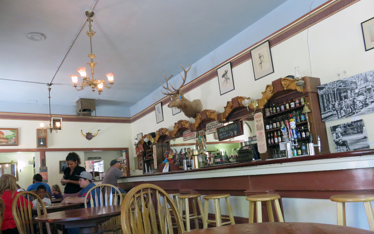
And down the street is the Pourhouse (great name!), with a plaque for Michelson (think Michelson-Morley experiment) at curbside.

We went out to check in at the BnB (no breakfast; does that just make it a B?), have a nap, and mellow out. Walked back into town, enjoyed a couple of dark brews at the Pourhouse.

IMG_1698

If we lived here, this might go far to becoming our Local.

Busy day. Good day. Good night.

Plano

June 26, 2016 by

Sunday, 26 June 20

Flew to Plano today for a week of Ericsson activities. I haven’t been here for a long time. Trip was fine, which means there’s nothing really worth mentioning. Nice chat with my Uber driver on the way from the airport.

Staying at the Aloft hotel here, nice people, okay hotel. Surrounded by cornfields. Dropped off my things, went out to see what there is to see. Well, first, walking is not the way to get around here; few sidewalks, lights not intended for pedestrians, and the like. Sunday was okay, but weekday traffic could make this problematic.

Nearby is Legacy town center, so that’s where I went. Trees, bricks, sidewalks: this isn’t so bad, even if it is 98 degrees.

IMG_1025

First scenic attraction was a little park and pond, good place to kick back if that’s what you want.

IMG_1027

The shopping area is only a few blocks, but nice enough. Restaurants, pubs, a few other ventures that think they can survive competition with Amazon.

IMG_1029

IMG_1032

Crossed Legacy drive, where I found an old bury patch, not open to the public, but accessible to cameras through the wrought-iron fence.

IMG_1039

IMG_1042

Just along the road outside the cemetery was a herd of Texas longhorns!

IMG_1034

With a cowpuncher herding them along.

IMG_1037

IMG_1035

Not far away, one of the longhorns had stopped to munch on the greenery.

IMG_1047

IMG_1049

And had another cowboy with a different opinion.

IMG_1054

The sprinklers came on, in the median strip. Nice to see water being readily available.

Well, it was late enough that I didn’t feel guilty about having a brew (not that I would have …). The Ginger Man pub advertised something like 70 brews on tap and even more in bottles. My kind of place. Found a bench in the shade and enjoyed one I had never heard of: Julius Echter Dunkelweizen, aus Wuerzburg. Pretty good.Suitably mellowed, I wandered over to Kenny’s Smoke House for pulled pork with spicy barbeque sauce.

Spoiled again!

ARMS at Rancho

June 19, 2016 by

Saturday, 18 June 2016

Got an early start at Rancho San Antonio, working on the purple star thistle area that I’ve been visiting since December. Found more, but there is less and less as time goes on.

At 8, met Tom and Ellen, and we three piled in a Midpen truck for a day of work on stinkwort (smells like camphor), bull thistle and poison hemlock.

IMG_0917

We started by finding the Fremont’s bush mallow along Chamise trail, the only one on Midpen property. It had been mowed to the ground a year ago during brush clearing, and we wanted to help prevent the same from happening again this year. So we captured GPS coordinates, cleared the area around it by hand, and put up a number of red flags marked Do Not Brush! Ellen will notify the crew to avoid it.

IMG_0911

Pretty flowers!

IMG_0913

On the way back later, we found a second bush mallow, which Tom had seen a couple years ago and which had then disappeared (under the wrath of the mower). So we also got its GPS coordinates, cleared the area around it, and marked it with flags.

IMG_0935

Our first target was an area of old quarry tailings, with a flat that could have been a house site, and evidence of one or two old roads. Such open spaces, especially where water can form small ponds, are attractive to stinkwort, and indeed we found enough to be worth taking out.

Above and below, a form of buckwheat called wickerstem. There are a lot of wildflowers around, very pretty, but so small, most of them, that they’re easy to miss.

IMG_0932

IMG_0953

Here’s another, above and below, this one skunkweed. Guess what it smells like.

IMG_0947

IMG_0959

IMG_0966

And this one, above and below, is Davy’s centaury.

IMG_0968

These, and more, identified by Tom, who IMO knows damn near everything about the botany of the region.

In Rogue Valley, we parked the truck at successive locations and worked our way along, dealing with bull thistle and poison hemlock. Tom gets nauseated by the smell of poison hemlock, so he peeled off to work on yellow star thistle instead. As for me, I hadn’t worked on hemlock before, so it was an experiment. Seems to have turned out better for me than it did for Socrates.

(BTW: ARMS means advanced resource management steward, an important-sounding title granted to us volunteers who go around pulling weeds. I probably shouldn’t go through a TSA checkpoint wearing a tee-shirt that says I’m ARMed.)

Sunday, 19 June

Did a trail patrol at El Corte de Madera Creek open space preserve. Sunny day, lots of people out, mountain bikies mostly behaving themselves, which makes me happy because there are a lot of gnarly, steep, blind, single-track curves.

IMG_0985

Redwoods and creeks are pretty much impossible to photograph. This does not even begin to do justice to the view of ECDM creek from the Virginia Mill bridge.

Good days to be outdoors

June 12, 2016 by

Sunday, 12 July 2016

When she has no formal projects planned, volunteer coordinator Ellen is available for ad hoc projects. We met on Saturday to work on broom along Razorback Ridge trail at Windy Hill. Pleasant day, and we made a dent, but there is so much that it was only a dent. It will need to be sprayed next season.

IMG_0737

I talk a lot about broom. Here’s a broom in bloom. This one is Spanish broom, rather than the more common French, and far more difficult to uproot. This one is above Horseshoe lake, a reminder to someone with a big weed wrench some day. Or maybe a pickaxe.

I was on the trail by 7 Sunday morning, up through Los Trancos, Montebello, Coal Creek, Russian Ridge and Skyline Ridge preserves. Pleasantly cool in the breeze, nice day. I should have gone to Mindego summit, but I wasn’t sure how much I had committed myself to, so I skipped it today. Next time: it turned out to be less than 16 miles, even with several little extra side excursions.

One of the side excursions was around Fir Knoll at Skyline Ridge. This is a trail that adds an extra 0.6 miles with no utilitarian purpose whatever; its only justification for existence is that it runs through a very pretty forest. Well, what more could we ask!

IMG_0700

And Ellen told me yesterday that there were still wildflowers on the walk around Horseshoe Lake. There are still wildflowers everywhere, but that’s a route I rarely take, so it was a good opportunity.

IMG_0708

I don’t think I had previously noticed the wild columbine turning up their sex organs for all to enjoy!

IMG_0714

IMG_0722

Flowers are to enjoy, right? Small animals in just about every one, enjoying.

IMG_0727

Well, maybe not this one. It’s about a sixteenth of an inch across.

IMG_0736

IMG_0891

IMG_0900

IMG_0902

To those who know better: yes, some of these pictures came from later, but I put them in pictorial order here.

IMG_0774

The eye spots on the dragonfly make it look as if it has a real face.

IMG_0699

And I presume the presence of the nymph is purely coincidental, nothing to do with the adult’s presence. I continue to boggle at the fact that the leading edges of their wings are open.

IMG_0778

IMG_0792

Ellen said there was larkspur on the Horseshoe lake circuit, one of the reasons I wanted to do it. Maybe what she said, or what she meant, was: there is even a light smattering of larkspur. Certainly nothing like a rich growth.

IMG_0820

I never noticed these little guys before. Tom tells me it’s Fitches spikeweed, and pretty unusual around here.

IMG_0822

I like its compound flowers.

IMG_0755

Well, I mentioned earlier that every flower has its small animals, not all of which are vegetarian. The Mariposa lilies are especially rich in photo ops. Above, we see a spider that has caught a little bee of some sort, while meanwhile, lunch goes on across the way. (Side comment: I think there are far more Mariposa lilies this year than usual, especially in comparison with California poppies.)

IMG_0881

Here’s a hungry spider, and below a good-sized carnivorous insect.

IMG_0751

IMG_0856

Saving the best for last, I was delighted with this picture. No sooner do you start eating lunch than you find that you are lunch!

Getting on toward summer

June 5, 2016 by

Saturday 4 June 2016

Supposed to be a hot day, so I decided to hike Purisima, possibly the coolest of the preserves. Parked halfway up Kings Mountain road, hiked down through Huddart Park, back up through Phleger Estate to the Kings Mountain volunteer fire station, where I refilled the water bottle. Then along Skyline to the North Ridge entrance.

As well as a garter snake (no photo), interesting and unusual sights included a slime mold on a stump.

IMG_0671

IMG_0665

IMG_0668

Looks like scrambled eggs, doesn’t it!

Not far down the Purisima North Ridge trail, I met Michael, who was a bit unsure what he wanted to do here today, if anything. Turned out he was from Fort Collins, Colorado, taking a day’s break from a week of work, staying at a B&B in Half Moon Bay. We walked and talked for a while; I confirmed his identification of poison oak — probably the single most important thing to do! — and we talked about grades, redwoods and Douglas fir, Audobon birds, and any number of things. Fortunate enough to find another garter snake to show Michael.

Hot enough day that I kept it to 17 miles, 3000 vertical feet — industrial grade, not a killer hike.

Sunday, 5 June

Coming down Kings Mountain Road yesterday, I passed workers out painting brightly coloured arrows on the road, and was reminded that the first Sunday in June is always the date for the Sequoia Century.

I don’t want to add congestion to the roads today, so I decided to visit Pulgas Ridge open space preserve, well away from the century routes, close and convenient, and a place I almost never go. Probably worth a circuit to have a look for bull thistle.

Got there during the coolth of the morning; the sun and heat didn’t really break through until I reached more or less the high point of the outer loop trail, so it worked out well. Short hike, but pleasant.

IMG_0676

And the special feature of today’s hike was seeing the lawn mowers in action. My favourite thing!

IMG_0673

IMG_0679

They eat pretty much anything and everything. It’s only a shame they can’t be turned loose on more of the preserves.

Wilder Ranch with Jacky

May 29, 2016 by

Saturday, 28 May 2016

Up early, spent two hours working on purple star thistle at Rancho San Antonio open space preserve. It’s a month since last I was here, and the ones I missed earlier on are starting to bolt upright. Fortunately, none of them were yet flowering, quite, so I didn’t have to haul away the carcasses to prevent them from developing viable seed. There were also quite a few newly sprouted rosettes, and I’m sure that the tall grass concealed more than I didn’t find. I do what I can.

I left just enough time to make it to the 9:30 start of a broom-pulling group volunteer event at Bear Creek Redwoods open space preserve, and would have been on time, but for slow merging traffic onto highway 17 toward the beaches at Santa Cruz. Not a problem, in any event.

Hot day, eight or ten volunteers found plenty of broom, and poison oak, in the shade of the forest. Good company, hard work, happy to quit around 2 when we had all run out of time, energy and the sliced watermelon that Ellen had brought along.

Sunday, 29 May

Jacky and I took our own trip toward Santa Cruz, veering north up the coast a mile or two to Wilder Ranch state park. It has been a long time; I searched my log files, and find 24 May 2009 as the last visit here, also with Jacky. That day, we logged 7.2 miles, 400 vertical feet. Today was 8 miles, 940 vertical feet. Cool, pleasant overcast day, lots of mountain bikies, most of them well-behaved.

Back at park headquarters, we wandered around the historic ranch house and exhibits.

IMG_0615

IMG_0617

IMG_0622

I especially liked the steering mechanism on this John Deere General Purpose (it says so) tractor.

IMG_0628

An old barn, big deal. What’s special about this is that the siding has simply disappeared in places over the years, in small pieces, remaining in place where the wood was a little better at resisting the attack of time.

IMG_0625

IMG_0634

IMG_0636

We remembered a great old bald cypress tree at the ranch house, and missed it as we came in from the parking lot. It’s just that, from the backside, all we see is a great mass of green that isn’t obviously a single tree.

IMG_0637

The blacksmith shop is not all that unusual, but I think this is the first one we’ve ever seen that was clearly dedicated to plumbing fittings.

IMG_0639

IMG_0643

IMG_0650

A factory, adjoining the smithy, overhead belts driving all the tools.

IMG_0647

And we’ve always thought Pelton wheels were pretty classy. Here’s a broken one, but I bet it was good for a few horsepower when it was in working order.

IMG_0657

IMG_0656

We stopped in Santa Cruz for a quick lunch, then back over the hill before the return traffic built up. A pretty good day!

Montebello-Saratoga Gap killer loop

May 21, 2016 by

Saturday, 21 May 2016

I like to start at Montebello open space preserve parking, hike down Canyon trail to cross Stevens Creek, climb out along the Table Mountain trails, then hike parallel to Skyline to Saratoga Gap. From there, a short section of the Skyline to the Sea trail, and back north along Skyline, crossing again into Montebello from Skyline Ridge preserve. I haven’t done it for a while now, so today was a good day to refresh the route. It’s about 20.8 miles, 3900 vertical feet.

IMG_0604

Fortunately, it was a cool, not to say chilly, day, cloudy, mist, even rain. More deer out than people. No danger of overheating, although I was glad I didn’t have to put on my plastic rain jacket until I was at the top.

IMG_0588

I stopped for calories and enjoyed the weather blowing out (below). The cold wind pushing it aside came off the Pacific, tempered by the Alaska current, so I kept the plastic jacket on for a while.

IMG_0594

Strange and interesting patterns over there; they are selectively mown areas of the meadow. Very strange, I thought.

IMG_0597

By the time I got back to the car, I had figured it out. As the season progresses, water doesn’t uniformly disappear from the near sub-surface; the grass goes yellow earlier in places where there’s no sub-surface water.

IMG_0599

If they mowed the entire area, green and gold both, the green bit would have to be mown again later on. So they economize by only mowing the grass that has completed this season’s growth.

Now if they’d only mow along some of the trails that are overgrown and waist-high in grass that’s only just starting to think about turning gold!

IMG_0608

Rancho and Montebello

April 30, 2016 by

Saturday, 30 April 2016

I haven’t done a killer hike for a while now. Spending time working on thistle and fallen trees, which is fine, but I’m getting soft. For reference, a killer hike includes 20 miles or 4000 vertical feet; today’s was both. Rancho San Antonio open space preserve.

IMG_0492

Almost as soon as I left the car, I saw a deer, and a pair of tom turkeys challenging for dominance, a nearby female of course elaborately uninterested.

Up the ridge along the transmission line access road, the trail that runs above the quarry, and to the top of Black Mt. Nice day, and a busy trail. These are some of the more distant and difficult trails in the preserve, ofttimes semi-deserted. Not today. Several groups, many one-sie and two-sie hikers. In contrast, the middle of the road Chamise trail, where I returned later to the parking area, was almost deserted. Nice to see people choosing the challenges.

I had not been to Waterwheel creek trail for quite a while, so I added that onto today’s hike, a way to bring the distance and elevation total up a bit. Pretty, pretty country: it’s really wonderful during the green of spring.

IMG_0502

Met a swallowtail on the way down. Pretty classy!

IMG_0522

Spring has definitely arrived; the lizards are also out scampering about.

IMG_0510

Eventually, back at the bottom, the zero-effort trails near the model farm. California poppies everywhere.

IMG_0533

It strikes me that these flowers are so bright because they contain super-pigment. Rather than just reflecting the red, orange, blue or whatever colour they like from the ambient sunlight, I bet they pump the pigment with high-energy short-wave photons and actively emit light in their preferred wavelength(s). This would make them more attractive to pollinators. In contrast, so to speak, it would be a waste of valuable energy to re-emit green wavelengths from stems and leaves. The result is that flowers are exceptionally bright, both absolutely and in comparison with their background.

I have no idea whether this is true, but it would make sense!

Having done the hard bit, I stopped at the Gate of Heaven cemetery, which abuts the preserve. Talked with the manager about the purple-star thistle I had seen on their side of the fence, offered to go work on it with her permission. The permission was easy; as the rains taper off for the season, the ground has turned very hard very quickly, and the cemetery has a massive infestation problem. So I cleared back from the fence fifteen or twenty feet and told myself it might alleviate next year’s crop on the open-space side.

Outdoors again

April 24, 2016 by

Saturday, 23 April 2016

I spent eight hours hiking a bit less than 14 miles in the preserves around the top of Page Mill road. Obviously, much of the time working on weeds, specifically thistle and broom, and even taking a picture or two. Very nice.

IMG_0139

IMG_0133

I don’t think I had ever noticed the miner’s lettuce being red before.

IMG_0134

IMG_0151

IMG_0163

Nice day.

Sunday, 24 April

I had a couple of honeydew projects, so didn’t go off into the wild today. But by midafternoon it was indeed time to get outdoors.

IMG_0176

I first went to the Palo Alto duck pond, where the only bird in the migratory waterbirds area is, well, hardly a waterbird. Too breezy for the small animals, too chilly for me to hang in there very long. So I headed back into town.

IMG_0202

Only to stop while this big guy crossed the road. Classy!

IMG_0225

And a bit further on, another stop while mother Goose and papa Goose escorted six or eight younglings across the road.

I stopped at the allotment gardens next to the library, where there are occasionally things worth seeing. Today, for example.

IMG_0276

IMG_0269

Still breezy. The wind blew the butterfly away from the lunch table, but only for a moment.

IMG_0293

A milliscopic fly on an artichoke.

IMG_0348

Don’t know what these are, but I’ve seen them around before. I had never noticed the flowers within the flowers.

IMG_0347

IMG_0382

IMG_0457

Aphid hiding under the leaf, hoping the giant ladybug larva won’t find it.

IMG_0407

I’ve seen these before, too. Someday I should learn all the names.

IMG_0414

And an unusual shot, the wing shields spread just before it buzzed off.

SF water district, Fifield-Cahill trail

April 17, 2016 by

Saturday, 16 April 2016

On Saturday, I did a trail patrol at Windy Hill. Ten miles, but I spent a total of six hours attacking various kinds of thistle, broom and ivy.

IMG_0001

I was here at Windy Hill two weeks ago, on a volunteer project to install a fence, to discourage people from cutting the steep grade at the top of the hill, causing erosion. Plastic fence, with snap rings and removable center posts, because this is also a launch site for hang gliders, so we needed it to be easy to remove and restore.

From the trail below, it looks very elegant. I was also pleased to see that it has not been vandalized, and there’s not too much evidence of people bypassing it.

Sunday

SFWD Fifield-Cahill hike

Today, Sunday, was an opportunity to hike the Fifield-Cahill trail through the SF water district property north of highway 92. It’s only open to guided groups, and by permit, so I was glad to have the chance to visit a place I’ve never seen. The organizers are the Bay Area Ridge Trail group, and this was a warm-up hike (13 miles, 1600 feet of gain) for the Ridge to Bridge fund-raising outing in two weeks.

Have to admit I had never heard of them, but in Marin county, it seems to be a pretty big deal. Hikes up to 26 miles, bike rides, equestrian event.

IMG_0010

We met at the Quarry gate just off highway 92. Easy to believe this was a quarry once upon a time.

IMG_0012

A few of us drove shuttles to get the group to the north trailhead, at the end of Sneath Lane in what is probably San Bruno. Popular place. The trail is a paved road that steeply ascends Sweeney Ridge. At the top is the site from which Gaspar de Portola discovered SF bay in 1769.

IMG_0058

IMG_0044

Bob, doing the talking here, was the organizer and leader, the one with the permit that kept the rest of us out of jail today.

IMG_0039

IMG_0053

There were sixteen of us total, several of whom were supporting the Ridge to Bridge event, one of whom was on the board of BA Ridge Trail, others of whom were planning to do the 26 mile hike. Some had done a 17-mile hike yesterday at Mt Diablo, just as a warm-up for today’s warm-up. A pretty fit group.

IMG_0062

Views from the top. Above, toward Daly City or South San Francisco, the bay north of the airport.

IMG_0086

The airport itself, Mt Diablo in the background.

IMG_0088

On the other side, we look down into Pacifica. At the upper left of the picture, the Farallon islands, with more ocean visible beyond.

IMG_0080

At 3 miles, we entered the permit-only SF WD area; not much further was a ranger, probably counting noses. We are all properly permitted, so he was friendly, wished us a good hike.

Being highly sensitized to bull thistle and especially purple star thistle, it was jarring to see both along today’s hike; I had to keep reminding myself that they were someone else’s problem. Although I admit that I did dig out a couple of bull thistles with my hiking sticks at one of the stops.

IMG_0115

Lots of wildflowers; this was the most spectacular site.

IMG_0100

IMG_0113

Much of the earlier part of the hike was in the open, bright and sunny, pleasant because of the chill breeze. The last half, more or less, was mostly in forest. Nice view down onto Pilarcitos Reservoir. And eventually, we descended a fairly steep final trail back to the old quarry.

IMG_0125

IMG_0130

Beautiful day, great scenery, and as we all agreed, a pretty easy hike.

The new Mindego Hill trail

April 3, 2016 by

Sunday, 3 April 2016

IMG_1784

Mid-Peninsula open space district formally opened the new Mindego hill trail this week, so of course that was my destination today. I was here on a volunteer trail-building project a couple years ago, but it was long enough ago that today was new. Mid-Pen makes a big deal of Mindego hill, and it’s justified.

I parked at the Los Trancos gate on Page Mill road, where I talked with ranger Frances, who had arrived to unlock the gates for the day. I told her I was planning to visit Mindego hill. “You know there are closer parking places than this,” she said.

“Of course, but why would I want to do that?” She agreed — she knows me.

So it was a few hours later by the time I got there.

Yesterday I had swapped my folding saw for a different one; the new one has a spring steel blade, or something similar, considerably sharper than the previous one. I did well on a deadfall with branches maybe four inches in diameter, where two or maybe three inches was about the max for the old saw. Nice.

I also opportunistically removed bull thistle, trying, not always successfully, to take only the big ones near the trail and not get sucked into taking out all the neighbors as well. I could spend all day and not make it to Mindego hill.

IMG_1781

The first stop was the little side trail to what is called Council circle, a stone disk with a bench around about a third of it, from which we get a wonderful view of Mindego meadow and pond.

IMG_1778

The pond is off limits. The volunteer project I was on went there, where we talked with a grad student who was doing a research project on endangered species. I believe the San Francisco garter snake was one of the species of interest.

IMG_1788

And then the hike to the top. I have to agree with the district that this is pretty special. Almost perfect — almost, I say, because there was just a bit of haze on the ocean, and I couldn’t be more than 99% sure that the irregularity I saw out there really was the Farallon islands.

Lots of people out. For many, this is a difficult hike (4.6 miles round trip, about a thousand vertical feet). I met a number of families heading down from the Alpine Road parking area, with kids from 0 to maybe 6 or 8. It would be safe to predict a number of tired, sore, cranky kids (parents, too) by the time they made it back up to the parking area later.

IMG_1807

Well, and of course Mindego hill was not the only interesting thing I saw today. First garter snake of the season. Jacky and I have just watched David Attenborough’s Cold Blood series about reptiles and amphibians. Very good; one of the things we learned is that the forks of a snake’s tongue are differentially sensitive, so the snake can turn toward, or away from, an intersting scent.

I even saw a ringneck snake later, also the first of the season, but there wasn’t enough light in the deep forest to get a picture worth keeping.

IMG_1891

IMG_1896

As I approached the Daniels nature center, an opportunity to refill the water bottle, a little insect landed on the grip of my hiking stick. I feel as if I ought to be able to put a name to this little guy, but it doesn’t come to me. [Update: it’s a snakefly. I forgive myself for not instantly knowing that.]

IMG_1905

IMG_1923

Another interesting bit of nature, these little red spiky guys. No idea what they are.

Of course, this was a trail patrol, so I had to do a little trail patrolling as well as sightseeing and taking pictures.

IMG_1940

Here’s a fallen tree across White Oak trail in Montebello preserve. Hikers had worked their way around to the right, but even that detour was pretty difficult. So I pulled and sawed and had at it for a while. Eventually, a couple of mountain bikies came down the trail toward me. In trail patrol mode, I told them this trail was closed to bikes in winter, but of course as a volunteer, I can do nothing more than convey a possibly interesting fact. (As a libertarian, I probably wouldn’t write very many citations, even if I had the authority.)

Their car was on beyond, so they weren’t eager to turn back. They decided to help me clear the deadfall.

Big difference. They were bigger and stronger than I, and especially with the three of us working together, we moved some big branches. From their accents, I asked whether they were German; turned out they were from eastern Austria. Nice.

As I thanked them, I suggested that, if they met a ranger, they might (or might not) get out of jail free by explaining how they had helped me.

IMG_1943

The result, above. There is still one large log to step across; a chainsaw crew will need to clear it. Backed with lots of vegetation, the log in the right foreground blocks off the previous detour.

These hikes turn out not to be all that many miles or all that many vertical feet, but there is a fair bit of work involved anyway.

Edgewood with Jacky

February 28, 2016 by

Sunday, 28 February 2016

Yesterday, I did 20+ miles of trail patrol and thistle attack at Rancho San Antonio. So I was happy to do something less ambitious today. There were so many wildflowers at Rancho that I thought it might be a good time to visit Edgewood county park, and I suggested to Jacky that she come along. Good idea; it has been a while since we were here.

IMG_1430

Mt Diablo across the bay mudflats and the bay and the east shore and ….

IMG_1503

Turned out that we’re just a bit too early for the real riot of wildflowers. Not that there weren’t flowers to be seen, of course. Just that the hillsides weren’t covered with color. Yet.

IMG_1505

IMG_1510

IMG_1513

IMG_1519

IMG_1525

IMG_1526

IMG_1420

IMG_1552

Little guys growing on the serpentine, starting off looking like sea creatures, but eventually turning into plants.

IMG_1553

IMG_1396

Lots of really small little guys.

IMG_1416

IMG_1443

These are so dark that they look black until the camera brightens them up to red.

IMG_1439

IMG_1446

IMG_1450

One of three women we met asked me, “Are we right in thinking that everything we see is poison oak?” I agreed emphatically. Everything from naked stalks to red proto-leaves to fully leafed-out bushes, everything from ground cover to vines in trees, strands wafting out across the trail to brush against. “Maybe we’ll find somewhere else to hike,” said the woman.

IMG_1457

IMG_1460

IMG_1484

IMG_1488

IMG_1549

We got to the visitor center just as it was opening for the day. Very pleasant volunteer told us to watch for mouse ears, hard to spot, but there for the diligent seeker. So we sought diligently, and sure enough!

IMG_1544

Even amongst the tiny plants, these are hard to spot, but well worth watching for. Nice day, nice place, nice company.

Day of the triffids

January 31, 2016 by

Sunday, 31 January 2016

I haven’t had enough exercise recently, so I wanted to get in a killer hike today. El Corte de Madera, a preserve I haven’t visited for a while. Nice day, bracketed between chilly morning and afternoon. The car thermometer thought it was in the low 40s, cold enough.

IMG_1110

Trails sometimes wet, sometimes muddy, but in fairly good shape. I cleared quite a bit of debris, and at the end of the day, reported five downed trees for the chainsaw crew to tidy up, along with a rockslide too big for me to handle myself.

IMG_1085

I have no idea what these little guys really are, but they always remind me of the old horror movie Day of the Triffids. So I call them triffids. Unusual to find them growing on an open more or less horizontal surface.

IMG_1092

IMG_1095

The wonderful things all around us!

Turtles in the soup

January 30, 2016 by

Saturday, 30 January 2016

At Rancho San Antonio, I worked on clearing purple star thistle in December, hoping to get a jump on the season. Today I went back to see whether it had been a complete waste of time. Not at all; I was pleased to find a fairly small number of plants that I had either missed or that had sprouted new since I was last here.

IMG_0970

There are a couple ponds, at one of which I stopped to munch an apple. And what to my wondering eye should appear but a turtle. When I tried to get close for a photo, it plopped into the water, but a few minutes later, it re-emerged and climbed out onto the bank.

IMG_0987

IMG_0998

IMG_1056

And not long after, another turtle climbed out nearby, the two happy to sun themselves.

IMG_1074

Not the kind of thing I see every day, although I’m sure I would if I hung around ponds.

IMG_1045

The wildflowers are starting to bloom, and I shot a hummer having lunch.

IMG_1042

Nice day. Great to be home.

Eisenbahnmuseum Darmstadt-Kranichstein

January 30, 2016 by

A free afternoon in Darmstadt

January 22, 2016 by

Friday, 22 January 2016

We finished work around 1 o’clock, and it was a sunny day, so I went wandering.

Route.jpg

IMG_0859

Friend Paul had told me about a 1:4 scale Lok at the Hauptbahnhof, so I went over to have a look. There is a slot where you can insert E0.50 and it actually runs for a while. I was tempted, but the reflections from the plexiglas shell were so distracting that I didn’t think a video would be worthwhile.

IMG_0901

I next found myself in a large park associated with the old Schloss. Very nice, although of course sleeping through the winter.

IMG_0924

IMG_0931

This is a section of the old city wall.

IMG_0945

“I assure you, I am better than my reputation!”

Nice place, but I’m ready for home. I hope the knock-on effects of the US east coast weather problems don’t affect my flight to SFO.