Posts Tagged ‘El Corte de Madera Creek open space preserve’

Black Friday: a time for fungi

November 25, 2016

Friday, 25 Nov 2016

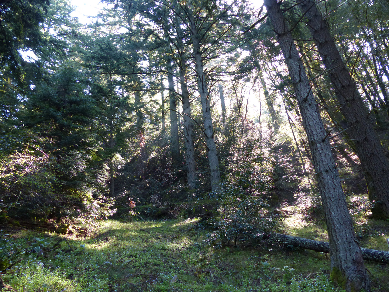
When I have several free days, or even two for that matter, I alternate long (more or less) hikes with weed removal. Today was for hiking, El Corte de Madera open space preserve. I haven’t been here since August. I did the usual perimeter trail hike, only 15 miles but 3950 vertical feet, very close to the 4k vertical feet that would make it an official killer hike.

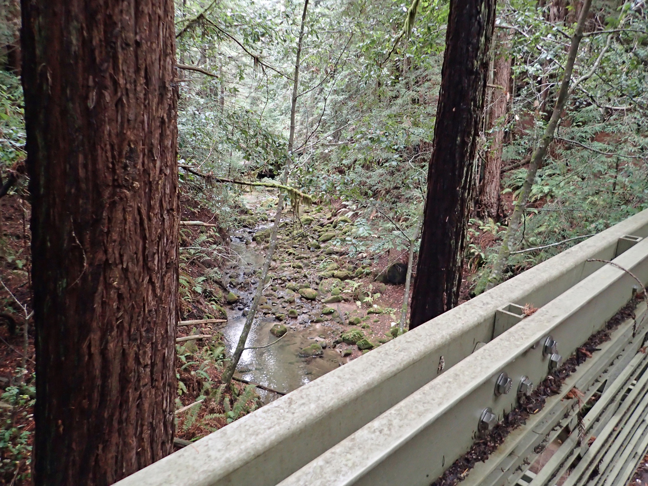
A cool, nice day. I started at 7 and had the world to myself for three and a half hours. At three hours, I was all the way down, as far down as it goes in this preserve, at the creek bridge, enjoying the first calorie break of the day.

Finally I began to see mountain bikies, though not a lot. I was all the way back up to Skyline before I saw the day’s first hikers.

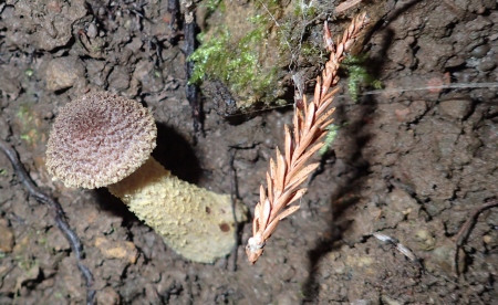
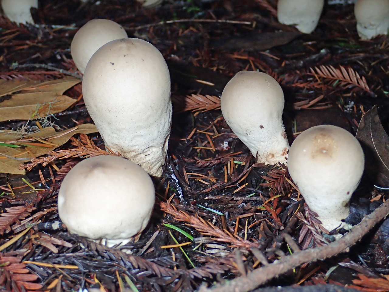
If I saw only a few people, wheeled or otherwise, it was more than made up by the number and variety of fungi.

This new Olympus Stylus camera has a close-up mode in which it shoots a burst at differing focal lengths and then combines the images. Above, the single-shot close-up of the fungus; below, the merged image. I am impressed!

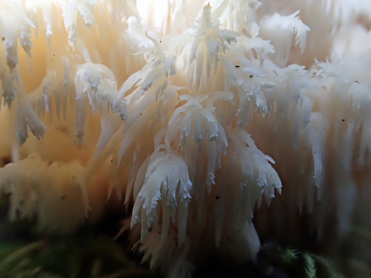
This almost looks like stalactites!

And many hours later, some interesting mushrooms inside the burnt-out interior of a redwood.

More fungi inside the burned cavern.

I wouldn’t upturn a mushroom myself, but someone else had turned this one over, so I got up close for a look at its gills.

This and the two following photos are from a vertical embankment.

For some reason, this strikes me as a bit obscene. No idea why.

A jelly fungus. Without the multi-shot composite close-up the branch is blurred, and the redwood frond in the background it just a stripe of color.

It really is a day for the fungi to come out!

I walked the last quarter mile to Skeggs Pt parking with a couple of mountain bikies who had had enough hard work for the day. From there, it was a fairly flat couple of miles for me back to the parking lot. On the way I talked with three groups about scenery and hikes in the preserve. It was mid-afternoon, and it only occurred to me later that I should also have called to their attention the fact that sunset today was at 4:52. I hope everything worked out well for them.

ARMS at Rancho

June 19, 2016

Saturday, 18 June 2016

Got an early start at Rancho San Antonio, working on the purple star thistle area that I’ve been visiting since December. Found more, but there is less and less as time goes on.

At 8, met Tom and Ellen, and we three piled in a Midpen truck for a day of work on stinkwort (smells like camphor), bull thistle and poison hemlock.

IMG_0917

We started by finding the Fremont’s bush mallow along Chamise trail, the only one on Midpen property. It had been mowed to the ground a year ago during brush clearing, and we wanted to help prevent the same from happening again this year. So we captured GPS coordinates, cleared the area around it by hand, and put up a number of red flags marked Do Not Brush! Ellen will notify the crew to avoid it.

IMG_0911

Pretty flowers!

IMG_0913

On the way back later, we found a second bush mallow, which Tom had seen a couple years ago and which had then disappeared (under the wrath of the mower). So we also got its GPS coordinates, cleared the area around it, and marked it with flags.

IMG_0935

Our first target was an area of old quarry tailings, with a flat that could have been a house site, and evidence of one or two old roads. Such open spaces, especially where water can form small ponds, are attractive to stinkwort, and indeed we found enough to be worth taking out.

Above and below, a form of buckwheat called wickerstem. There are a lot of wildflowers around, very pretty, but so small, most of them, that they’re easy to miss.

IMG_0932

IMG_0953

Here’s another, above and below, this one skunkweed. Guess what it smells like.

IMG_0947

IMG_0959

IMG_0966

And this one, above and below, is Davy’s centaury.

IMG_0968

These, and more, identified by Tom, who IMO knows damn near everything about the botany of the region.

In Rogue Valley, we parked the truck at successive locations and worked our way along, dealing with bull thistle and poison hemlock. Tom gets nauseated by the smell of poison hemlock, so he peeled off to work on yellow star thistle instead. As for me, I hadn’t worked on hemlock before, so it was an experiment. Seems to have turned out better for me than it did for Socrates.

(BTW: ARMS means advanced resource management steward, an important-sounding title granted to us volunteers who go around pulling weeds. I probably shouldn’t go through a TSA checkpoint wearing a tee-shirt that says I’m ARMed.)

Sunday, 19 June

Did a trail patrol at El Corte de Madera Creek open space preserve. Sunny day, lots of people out, mountain bikies mostly behaving themselves, which makes me happy because there are a lot of gnarly, steep, blind, single-track curves.

IMG_0985

Redwoods and creeks are pretty much impossible to photograph. This does not even begin to do justice to the view of ECDM creek from the Virginia Mill bridge.

Albino redwoods

November 8, 2015

Saturday, 7 November 2015

Prompted by a comment from last week’s post, I hiked the perimeter of El Corte de Madera open space preserve today, hoping to find another giant salamander.

IMG_1353

No luck, but the cool autumn day was wonderful, no matter what. I would have been happier with fewer crazy mountain bikies, but you take what you can get.

Sunday, 8 November

Ellen had very nicely organized a short hike for open space volunteers, into an area that’s completely closed off from public access, to visit a couple of groves of albino redwoods. There were about ten or a dozen of us.

IMG_1409

It was a little rainy, but beautiful.

IMG_1480

Even without albinos, this would be worth a visit. Very nice.

IMG_1370

Here is the larger of the two albino groves. The trees in the background are not albinos; the albinos have no chlorophyll, and cannot photosynthesize, so they grow as much as they can, and die off. We see lots of the dead earlier growth here.

IMG_1478

The group looking and talking.

IMG_1440

This is what they look like close up. Full redwood foliage structure, just no color.

IMG_1515

We went on to the second albino observation. This one is actually a burl on the side of a tree. Someone said this might be caused by a virus, and the idea of having an anomalous structure on an otherwise normal tree would tend to reinforce that idea.

IMG_1548

IMG_1549

More beautiful views, these along the creek.

IMG_1528

There were at least two newts at the bottom of those little ponds. Don’t see them?

IMG_1538

Here’s one.

IMG_1563

Later, we found a couple more, out hiking along the trail.

Great place, great day! Thanks, Ellen.

Cloudy and chilly

May 17, 2015

Sunday, 17 May 2015

I spent 3.5 hours yesterday working on broom and thistle, but when I had used up my quota of enthusiasm for the day, it was so cold and windy that I called it quits, rather than going for a hike. (Well, it made a difference that I had forgotten to take along a jacket.)

Today, Sunday, I’d like to do a killer hike. Someplace I haven’t been for a while? Went to Wunderlich park, left the car, hiked to Skyline, thence to El Corte de Madera Creek open space preserve. Well, at least the first part was a place I haven’t been for a while. As to ECDM, I completed the first draft of my trail signs audit a few days ago, and it was an opportunity to ponder my conclusions. Worthwhile, too. I developed a couple of new insights that will go into draft 2.

P1180145

The new bridge across ECDM creek is not complete, but is open for traffic. Beautiful red wood. Too bad it won’t stay this color; enjoy it while we can.

P1180148

Just below the bridge is the stream crossing that was the official detour while the bridge was under construction. Half a dozen mountain bikies were attacking the grade on the right side, without a great deal of success. Of course, they were just playing. I munched a munchie while watching them. One of them invited me to give it a try. Ha!

Nice day. I was concerned at the outset that I had only one water bottle, but it was so chilly that I still had about a quarter of it left when I got back to the car. Almost 22 miles, over 5000 vertical feet.

P1180152

This is your brain on mushrooms.

Yet another busy weekend

May 3, 2015

Saturday, 2 May 2015

I had originally signed up for a trail-building volunteer project, but my tennis elbow suggests I should take it easy for a week or three, so I begged off. Instead, I thought I’d park at Palo Alto Foothills park and do a serious hike from there, but the gate was still closed when I arrived, so I went on up the hill as far as the first gate into Los Trancos, and improvised a hike that turned out not to be as long as I had intended (16.5 miles, 2800 vertical feet). Nice day, and the wildflowers are out everywhere.

P1180010

I stopped at the Stevens Creek crossing along Canyon trail to photograph the underwater newts (three in this picture).

P1180019

Many hours later, I entered Coal Creek preserve on my way back toward the car. Given that I am pretty sure I saw a mountain lion at Coal Creek a few weeks ago, I wouldn’t want to sell life insurance on that cow.

Wildlife: as well as the newts, a garter snake. Nice.

Sunday, 3 May

Given that yesterday was less than what I wanted to do, I filled in today by visiting the rest of the trail junctions in El Corte de Madera open space preserve. This is part of my trail signs audit project, which I am going to have to sell to the district.

P1180043

The overnight fog was just lifting. Very nice.

P1180039

Tafoni is a kind of sandstone, subject to interesting letterboxing, and one of the attractions of this preserve. There is more tafoni around here, for example at Bean Hollow state beach, but not as close and convenient.

P1180041

In 1953, a DC6 crashed in the fog on this ridge. This was still during the time when aircraft had names, and this one was the Resolution. So the trail that runs past the site is the Resolution trail. I doubt they had the equivalent of ATVs to help with salvage, and there may or may not have even been a trail along there. Likely as not, whatever was recovered was carried out on horses or mules.

After recovering the bodies and personal effects, the next priority would have been forensic evidence. Then whatever small things might have been of value would have been salvaged, for example instruments or computers. Things that were too big or too heavy to justify removal would have been left behind, where they have probably been picked over by souvenir hunters for sixty years.

P1180051

I haven’t come along this trail for a few months, and don’t recall that there was much of anything to see. Today, there was all kinds of aircraft debris along the trail, more visible down the hill below the trail. Surprising, in a way, that there still remains this much that’s both interesting and movable.

P1180054

My guess that that scavengers have been prowling around down there, and for whatever reason, just didn’t have a chance to haul away the latest set of goodies.

Hours later, I had been down to the further reaches of the preserve and was on the way out, having talked to a number of mountain bikies, found a rotten plank in a bridge for my trail report, and generally had a good time (14 miles, 3300 vertical feet). The fog had blown in off the ocean and it was chilly and windy.

A group of hikers came past, and the red madrone tunnel suggested a perfect photo. (And yes, they agreed. But I shot them before they were all posed.)

P1180099

Hiking in the rain

March 22, 2015

Sunday, 22 March 2015

Intimidated by heavy mountain bike use, steep grades, blind curves, I don’t visit El Corte de Madera open space preserve very often. Even when I was a mountain bikie myself, I didn’t come here, same reason, as well as the fact that it’s more technical than I’m really up for. But I haven’t been here for a while, and it was a rainy day, with fewer bikies than usual. Parked at the newly opened lot off Skyline and hiked the perimeter trails clockwise. A bit less than 16 miles, but 3800 vertical feet. I earned my beer.

Nice to hike in the rain and the coolth. Two or three times it stopped raining and I stowed my rain shell, and two or three times I dug it out again.

P1170577

Especially recalling the lost hikers I helped last September, I have long been unhappy with the state of the trail signs here. Today I decided to photograph the signs at all of the trail junctions on my route. I documented inconsistencies with the paper map, absent signs, erroneous signs, vandalized signs … (what else is there?). Needs a clean-up.

For broom too large to take by hand or with a small weed wrench, I now have a small folding saw – I can at least girdle them. I added the saw to my hiking kit, and found several uses for it today, clearing the trail of debris that would otherwise have required a trail report.

P1170615

This year’s new growth is a lighter, brighter green than the old foliage. Makes the trees look as if they’re decorated.

Completing the skyline trails

September 27, 2014

Saturday, 27 September 2014

According to the open space district, El Corte de Madera Creek open space preserve has 35.9 miles of trails. Because of backtracking and looping, it took me 50 miles of hiking to do all of them, spread, as predicted, over three visits (each with 4000-5000 feet of vertical gain). Today was the northerly set of trails, my car parked at Skeggs point.

Today completes my quest to hike all of the MROSD trails along Skyline, a significant step in working toward the anvil award, which recognizes trail patrol volunteers who cover all of the trails in the whole open space district. Meaningless, of course, but it’s a challenge, gives me a focus.

Started just after 7 on a cool, cloudy day that remained cool and cloudy throughout, except for about ten minutes of filtered sun in early afternoon. Very nice, indeed. Found a madrone fallen across the trail, marked it with GPS and a photo to report to the district; someone will get out here with a chain saw one of these days. There was a lot of other fallen debris, as well, all day long, but I was able to clear it myself. Glad I remembered to stick my leather work gloves in my pack.

P1160063

There is a bridge under construction, El Corte de Madera creek, at the bottom of Methusaleh trail. I came this way last week with the hikers I was helping. There has been a noticeable amount of progress in a week; interesting to see all the miniature construction equipment, designed for back-country use.

P1160064

There is a nice monument to the passengers and crew of the Resolution, a DC-6 that flew into a hillside here on a foggy day in 1953.

P1160065

P1160076

The other special attraction of this preserve is the tafoni formation, essentially sandstone with interesting erosions. I have to admit it’s worth a look.

P1160079

At a few points along the day’s trails, I found broom, an invasive plant that needs to be kept under control lest it take over the world. I cleaned out all of one stretch, and reported the second stretch on my trail log. Then, almost back to the car, I noticed a delta-shaped clearing where two trails merge, that was full of broom, much of it fairly good-sized.

Because I was near the car, it was easy to go get my weed wrench and return. I put in something like an hour and a half pulling broom by hand, using the weed wrench on a dozen or so of the larger specimens.

P1160091

I found a couple of these little caterpillars on the broom (so you can see what broom looks like, if you care). I was careful not to damage the insects when I unplugged their lunch, but I did unplug their lunch.

Because it’s on the outside of a blind curve, turns across traffic lanes are not allowed in or out of the Skeggs point parking area. Forced to go north, I thought I’d go home down Kings Mountain road, but when I got to the junction, I saw that there was a bicycle century rest stop there, with riders coming up Tunitas creek road from the coast, and going down Kings Mt road. The best way I knew to be bicycle friendly was to go on up Skyline and come down highway 92 instead.

Wunderlich park, El Corte de Madera

April 15, 2014


Sunday, 13 April 2014

Today’s hike started at Wunderlich park in Woodside. Two hours later, I was at Skyline, where a pavilion marked a rest stop for a trail run from Huddart park and back. They told me they expected the first runners to show up around 10, about an hour after I got there. No problem, I’ll avoid the clutter by going over the ridge to El Corte de Madera on the west side. They have closed off the direct diagonal entrance across Skyline, but there is a new connector trail that I haven’t taken before.

P1120590

The west side gets a lot more water, condensation from the fog, and is pretty and green, far more than the sheltered side. Nice.

P1120594

Being wetter, there are more opportunities for interesting fungi to find a foothold.

P1120595

P1120586

I have been past Skeggs point a number of times in recent years, but never actually stopped here for quite a long time. It’s probably the single most significant staging point for mountain bikies in the north Skyline region, arguably equivalent to Saratoga summit on south Skyline.

P1120593

An hour or three later, down in the forest, this same group passed me, heading back toward the parking lot.

P1120588

Nice day, nice scenery. When I got back on the east side of the ridge, I met a fair number of trail run stragglers on their way back. Some of them looking okay, some of them — and this is only the halfway point — looking like it was going to be a long day.

It was a long enough day, also for me. But nice to get out and do it!

Wunderlich to Huddart

August 18, 2013

Saturday, 17 August 2013

I did pretty well on last weekend’s hike, so maybe I’ll try for a killer hike today. Supposed to be hot and muggy (!) inland. I went to Wunderlich park and hiked along the Skyline trail to Huddart park. I was worried that I might not exceed 20 miles, which is more or less the criterion for a killer hike, so I took Summit Springs road trail across Huddart to Richards road trail and looped back on Skyline trail. Then about halfway back, I crossed by way of the new Molder trail — new since last I was here — into El Corte de Madera open space preserve. Long enough, 23.5 miles.

P1100591

Early on, I encountered a family of deer, peacefully munching on the poison oak. Three or four does not in the picture, but what surprised me was the two bucks, apparently getting along just fine.

P1100600

P1100611

The other interesting wildlife of the day was this woodpecker. Update: Doris tells me it’s a northern flicker. Thanks, Doris; you are always very helpful and knowledgeable.

Good to get out, get a little fresh air and exercise.

Wunderlich — El Corte de Madera Creek

June 15, 2013

Saturday, 15 June 2013

Left the car at the Wunderlich parking lot. Starting at 7:15, I hiked up the hill and down the other side in El Corte de Madera Creek open space preserve. Mountain bike heaven, although there was less traffic than I feared.

P1020295

The small animals department was a little thin today. I thought the west side of the ridge would be more lush, but it’s far enough from the fog zone and the ocean that it’s pretty much the same as the east side, dry and dusty.

I think I have been to the tafoni area before, but it was many years ago, and I don’t remember anything about it. So I checked it out.

P1020314

According to the bumpf, this is formerly submerged sandstone in which acidic water differentially dissolved calcium from some areas and either carried it away or deposited it in other areas. The calcium-rich areas do not erode as rapidly as the rest of the rock.

P1020306

P1020308

I have always just called these letterboxes, but the official name is tafoni. Very nice.

P1020309

P1020310

P1020311

P1020312

P1020307

I hiked the Resolution trail, named for an aircraft that crashed here in October, 1953. It was a DC6 called the Resolution, inbound from Hawaii. The coast and ridge were fogged in, and in the days before radar navigation, and certainly before GPS, the pilots appear to have mistaken where they were. There were of course no survivors.

P1020321

After seeing a giant salamander nearby two weeks ago, I had to hike the giant salamander trail here. Didn’t see anything along the trail, but the subsequent Timberview trail runs along a tiny creek, and I bet these little guys are giant salamander juveniles. One indication is the vertical tail fin.

P1020360

P1020352

A young water-strider turns lightly to thoughts of love.

P1020375

At the top of Methusaleh trail is the Methusaleh tree, just east of Skyline. According to the sign, it is estimated to be 1800 years old, and has a ground-level diameter of 14 feet.

P1020376

P1020282

It isn’t tafoni, but the slate is pretty interesting, too.

First killer hike with the new boots, 22 miles,  4700 feet of gain. They still make my feet sore, but they’re getting better.