Archive for the ‘Cycling’ Category

Baylanding and the new library

November 9, 2014

Sunday, 9 November 2014

Now that I have completed the anvil trails challenge, I get to kick back and take it easy for one weekend (hard work on yesterday’s volunteer project notwithstanding). I had agreed to go out to the Ravenswood open space preserve to photograph and geo-tag actual and potential artifacts that might turn into memorials for various people associated with the open space district. Especially donors, of course.

Cooley landing, N viewing platform

Did it on my bike. Found a number of pretty classy places, although the one above is a long way out on an unpaved dead-end trail.

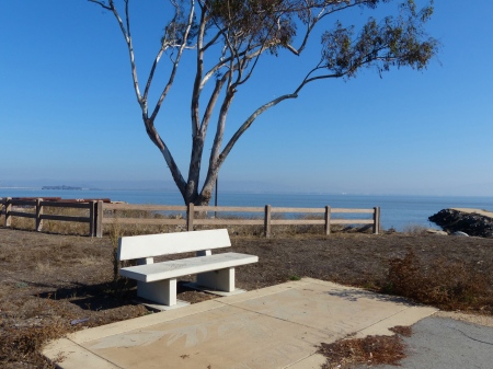
Cooley landing Bench 5

This one is fifty feet from the parking lot. Much easier to auction off!

Dumbarton overlook 2

The preserve exists in two non-contiguous chunks; the first two photos are from Cooley Landing; this one comes from the old Cargill salt pond SF2 near the Dumbarton bridge. It has been extensively reworked as a wildlife refuge.

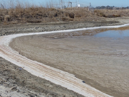
Then I went on up the shore past Menlo Park. The salt ponds further up are still mined, but I contented myself with a look at the old one that may someday be actively reclaimed as wildlife refuge, and meanwhile is just a place where the wildlife takes refuge without benefit of taxpayer dollars, the Ravenswood slough.

P1160378

Salt crystallized along the shore. The buildings of Sun Quentin in the background (that’s a local joke).

P1160390

Beautiful in its own way. The reddish streaks would be algae.

P1160382

P1160375

A tumbleweed lands along the shore and is preserved forever in a shell of salt!

P1160379

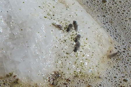
Brine flies. I can’t tell whether the little green specks are also insects, but they might be.

Home for lunch.

Mitchell park library

Then I decided to visit the newly opened Mitchell Park library. The official grand opening is planned for December, but they informally opened the doors early to shake the bugs out. Or something. This is a $28 million dollar boondoggle ($4M over budget, 2 years late — and why should a library cost $24M in the first place?). Ought to be pretty nice.

It takes an hour to walk there. That is hardly their fault! I walk past the parking lot, looking for the main entrance. Go around the side in the other parking area, to discover it’s just service access. The main entrance is off the first parking lot. Of course! How could I have expected it to be pedestrian oriented?

Some of the exterior walls are really attractive, flowing dark red, looking like slate. Tap them with a knuckle, and they reveal themselves to be anodized panels. Had they actually been slate, I suppose there would have been another $4M overrun.

In the entry courtyard, there is a slot for book return. There are also two screens where you can… what? … return your books? That’s how it looks: I can’t imagine why dropping books in the slot is somehow less than sufficient. That’s what I did, anyway!

Indoors: lots and lots of open space. No crowding here. The ground floor is dedicated to children, including teens, and to media (by observation, we see that paper is not a medium). It would appear to be dumbed down to get people to at least come in the door. This would be in Palo Alto, the alleged intellectual center of the world?

Upstairs, where we actually find books, we don’t find many. The aisles are short and wide, the shelves are maybe half full. We hope this is just because the staff hasn’t had time to move all the books from storage and from the temporary library yet.

And then there’s the other half of the building, a community centre and a cafe. I saved those for later, or maybe never.

Count me underwhelmed.

Getting out

June 15, 2014

Saturday, 14 June 2014

The open space district has an award for anyone who patrols all of its trails.The actual award? An anvil. Well, not the hundred pound chunk of iron kind, but there’s something appropriate about the idea anyway. There is something north of 200 miles of trail in their jurisdiction, so it will take a while, but the real issue is likely to be that some of them are far away, enough to be a bit of a nuisance getting there.

But there is certainly low-hanging fruit. Foothills open space preserve, for example, only has one trail, only about half a mile long, and I have never bothered to stop there. Today I did. New trail, new preserve, one low hanging fruit.

P1130805

Then I went on up Page Mill road to the end of Montebello road, where I hiked several other trails that I have never done before (above: the view of Silicon Valley from the Adobe Creek trail, Mission peak across the bay), and other trails that I have done before but not for a long time.

The most interesting name is Watermill creek trail; there is a small spring in an area where we could imagine there once was a waterwheel. Today, we see only a few pipes. It would not be a surprise if one of the pipes takes the water over to the nearby backpack camp.

Having done this corner of Montebello preserve, I drove back down the hill. It was still early in the afternoon, so I went to Windy Hill, where I put in a couple hours in the coolth near the creek along Eagle Trail cleaning out broom. I hope I succeeded in avoiding the poison oak.

For the log: 16 miles. 2700 vertical feet.

Sunday, 15 June

There is more low-hanging fruit along the baylands. The best way to visit these two areas is by bicycle. First, we go to Ravenswood, the section just south of the Dumbarton bridge. Nothing much there, except the Hetch Hetchy aqueduct coming ashore from the east side of the bay.

P1130806

P1130807

When I first saw these from a distance, I was reminded of a train of tank cars. Close up, we see that they are not as big as tank cars, but they are more than big enough!

From here, back around on the streets to the other section of Ravenswood, namely Cooley’s Landing. This one connects via continuous trails that go all the way down to Sunnyvale. Next stop was the Palo Alto duck pond.

P1130813

The black-crested night herons breed in the trees above the duck pond.

Nearby, shallow marsh where I saw shorebirds setting their eggs when I was here a few weeks ago. They don’t seem to still be setting, but I also don’t see any fluffy little chicks. Curious.

Further south, I deduced the presence of a school of fish from the large number of cormorants fishing from the surface and a matching number of terns fishing from the air. A good time was being had by all, well, all but the fishes.

I downloaded a trail map from the open space district, which shows all kinds of trails in the Shoreline park area, most of which I’ve never ridden before. As it turns out, only one small section is open-space district, and it’s on my bicycle commute route anyway, but it was an excuse to go ride pretty much all of the trails shown on the map. Nice day.

Also got to be work after a while. Although it’s all baylands, there are a fair number of hills here, some of them fairly steep, and many of the trails are also covered with loose deep gravel. The whole thing turned out to be 39 miles, more than I would have predicted, and I hadn’t taken any calories along. Enough; two more low-hanging fruits in the bag.

Cupertino cherry blossom festival

April 27, 2014

Sunday, 27 April 2014

After the Jasper Ridge outing, I stopped at home for lunch, then went out on my bike. I had noticed that there was a cherry blossom Japanese festival in Cupertino this weekend. Why not!

P1120929

As it turns out, there was about one cherry tree with a few feeble bunches of blossoms. Not much of a season, but it’s the thought that counts. And there were thousands of people, all having a great time.

P1120987

P1120936

P1120934

Beer and sake, my kind of town.

P1120937

There was a big spread of tents, but the most interesting part was the amphitheatre, where the akido school was putting on a demo.

P1120960

You will not be surprised to learn that she threw him. All choreographed, of course, no anger, not much pain.

P1120953

I thought these guys might be interesting, but time was dragging a little, so I headed back.

P1120995

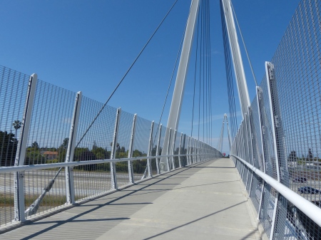
The Don Burnett bicycle-pedestrian bridge spans I-280 here. I have driven under it many times, but never before crossed it. Pretty classy, as they say.

P1120999

P1130082

Home in time for a brew, something to eat, and a nap before going to the airport to meet Jacky’s delayed flight from JFK.

Everything hurts

April 6, 2014

Saturday, 5 April 2014

Another volunteer day with the open space preserve. Back to Bear Creek Redwoods, just south of Los Gatos at the base of the hills. A new part of the preserve today, one I haven’t seen before. Very pretty.

P1120583

There is a lot of broom around, much of it in bloom at this season. We are not ambitious enough to even dream of eradicating it; our volunteer coordinator Ellen wants to protect the meadows from encroachment. So we’ll focus on the meadows themselves, along with their bordering forests.

P1120582

I worked alone all morning in an open forested area, where the broom had been previously mowed and sprayed. The mowed ones were the hardest: only a few inches tall, they had root systems far beyond their visible size. In damp duff, even some of the larger plants came out with a pull by hand; in hard-packed clay, even many of the smaller ones required the weed wrench.

There’s poison oak everywhere, but I’m wearing long pants and leather gloves, and keeping a suitably paranoid eye out. Boot-high growth isn’t too much of a concern.

P1120584

By afternoon, I was ready for a change of scenery, so I joined the main crew, a few of whom are visible here. We see impressive piles — waist-high — of broom to the left of the roadlet; these piles continue for a hundred feet or more, as each of us attacks on a parallel front. I had rather imagined wandering around taking pictures, but there was a supersize Extractigator (good name!) not being used, so I added a few large bushes to the pile myself.

These sessions only run 4.5 hours, including a lunch break, but that’s enough. It’s seriously hard work, bending, twisting, turning, crouching, squatting, pushing, pulling.

Sunday, 6 April

So I’m not at all surprised that I hurt everywhere this morning, everywhere but my butt. The implied course of action was obvious, and after 51 miles and 2000 vertical feet on the bicycle, I’m back in total balance.

The California desert

January 5, 2014

Saturday, 4 January 2014

Hoping to keep the knee happy, I hiked the outer periphery of trails at Arastradero. Sounds impressive, but Arastradero is a small preserve, and its trail circumference is only 5.7 miles, 700 vertical feet.

P1110915

It is surely unprecedented to see sprinklers running in January, and not for some lush lawn of Kentucky bluegrass, but for the hardy drought-resistant California natives. The absence of rain this year is a real concern.

And the outback isn’t very interesting, either, dry and sleepy, holding its breath for rejuvenation.

Sunday, 5 January

Knee seems okay, so I tried a moderate bike ride, 36 miles, 1200 feet of climb. Lots of people out doing it, another nice day.

But I also went up to inspect the roof, just in case it might rain again someday. Went for some roof patch compound where there are some things I don’t like around the solar hot water panels, and caulked them.

Two flat tyres! in one day!

January 3, 2014

I have been mostly working from home for a while now, but it’s good to go into the office once in a while, especially on bagels day, and it’s an unimpeachable excuse to spend a couple hours on the bike.

But when I went out to the garage this morning, I discovered a flat tire. Finally, the first flat on the new bike that I gave myself as a birthday present, October 2012. That may or may not say anything about the durability of tires, the condition of the roads or my skill in avoiding debris; it is certainly related to the fact that I spend a lot more time hiking nowadays than in times past.

Never a whole lot of fun, a flat at home is about as good as it gets, with a warm, well-lighted environment to perform the repair. Even a bathroom sink, if I need to immerse the tube to find the leak, which I did. But it was a rear tire, and I have to pull the skewer completely out because of the carbon fiber frame and, and, and… long and not very interesting story.

The leak was near the valve stem, possibly just due to material fatigue. In any event, repairs near the stem are pretty much guaranteed to be useless, so I just swapped in a new tube. Experimented with the mini hand pump, which I have never used before. Interesting how hot the business end gets as the tire pressure mounts, but I finished the job with a floor pump, which has the added merit of a pressure gauge.

So I was a bit late getting to the office. They had not run out of bagels.

On the way home, another flat! Damn! It never rains but it pours! Again, the rear tire.

At least the day had warmed up and I had a sunny spot to work in. Several passing cyclists slowed to check that I was okay, a welcome display of benevolence that’s normal in this community. We help each other out.

This time, there was a gash in the carcass where I had run across what was most likely a sharp bit of glass. It had gone all the way through and punctured the tube. Not a problem… until I discovered that the tube of cement in my long-unused patch kit had dried up. And there was a dearth of passing cyclists at the time.

Not to worry; I just put in the spare tube I always carry. I’ll patch the old one when I get a new patch kit. Flats go with the territory, no fun, but we just deal with them.

Mellow weekend

October 20, 2013

Saturday, 19 October, 2013

I hadn’t been out on the bike for quite a while — I blush to think how long it’s been — so I did a little sport ride, 52 miles, 2000 feet of gain. Nice to be outdoors, nice to get an endorphin high.

Sunday, 20 October

P1110308

I had some work to do, so cut today’s hike down to a minimum, 9.75 miles, 1900 vertical feet. Windy Hill, with a nice view over silicon valley and out toward the coast.

P1110309

P1110310

P1110311

When first I saw this chunk of log atop a fencepost, I thought it was a joke. But I have seen a couple more here and there, and finally figured out that they are intended as perches for raptors. If the result is a reduction in the overpopulation of ground squirrels, more power to them!

Good-bye to old friends

October 1, 2013

We donated the bikes that took us across the continent to the Mike’s Bikes Africa campaign, along with accumulated components from over the years, everything from wheels to saddles to cranksets to shifters to ….

My Richard Sachs bike had something like 90,000 miles on it, all over California and Germany, as well as across North America. But in this day of carbon fiber, there’s not much interest in fine custom-built steel frames. Even I, stalwart as I am, bought a carbon fiber bike a year ago. I rode the Richard Sachs once since then to see if it was a candidate for an alternate bike. No, sorry.

We went through lots of pain together, lots of pleasure. It was a good friend for many years. I hope these bikes will be appreciated by their new owners as much as we enjoyed them. Good-bye, and good luck.

Bozeman: renting a bike

July 15, 2013

Monday, 15 July 2013

I have not been getting anywhere near as much exercise as I like, so today I rented a bike. Choice of road, mountain or something in between, and I decided on a road bike.

Nice Felt carbon-fiber bike. Helmet and lock cable included. They put toe-clip pedals on it, so I can ride with running shoes. No rackpack, so I had to wear my own computer baggie backpack. Well, I can manage that. Not many photos, though, because I have to stop the bike, take off the backpack, fish out the camera, and it just gets to be too much trouble to do very often.

Guy at the Chalet Sports shop suggested riding south from downtown to get onto Kagy, east on Kagy to Fort Ellis road, then Kelly Canyon to Bridger Canyon, out further on Bridger Canyon until I was ready to turn back, and return to town on Bridger Canyon road, which becomes Rouse St. That’s what I did; Google maps says it’s 22 miles. Not much traffic, some climbing but nothing extreme. Good choice for a nice little ride.

P1090987

I stopped in at the fish hatchery, which we had noticed yesterday, looking down from the M. We can see the M across the road and up the hill, at the top, just left of center in the picture above. From here, you’d think the M was near the top of the mountain.

The fish hatchery had a pond with eating-size trout.

P1090932

When I arrived, someone was buying  a package of fish food from a dispenser. He started throwing handsful of food into the water, which exploded each time.

P1090958

He remarked that these fish are probably the best fed in the world, but they act like they’re starving.

I asked him if there was anything else here to see. He thought I might get a guided tour by asking at the office, so I did. No, grump, grump, we don’t do guided tours. Well, it cost nothing to ask. My taxes pay their salaries, so why should I expect them to even be polite, much less cooperative or deferential?

Optimizing bicycle gearing, chapter 42

May 26, 2013

*Warning — technical stuff ahead*

In terms of gearing, what a cyclist would really like is a more or less infinite range of choices, with more or less infinitesimal granularity. Those who don’t spend much time on a bike just take what they get. Those of us who do spend a fair amount of time on a bike (albeit less than in previous years) also take what we can get, but we look harder to see what’s available, and try to optimize for the kind of riding we do.

I fitted out my classic Richard Sachs bike for touring and mountains. It was (still is) a 30-speed, configured in what’s called half-step plus granny. The idea of the granny gear is pretty obvious: a set of low-end ratios for the uphill grinds. Half-step was once called Alpine gearing, back in the days of 10-speed bikes. The idea is to have a wide-ratio rear end, with the two chainrings at the crank selected to interleave the ratios. The crank then has three chainrings, the granny and the two half-step rings that are almost the same size. My half-step rings were 45 and 48 teeth, which looks pretty much useless to someone who doesn’t understand how it works.

Well, how does it work? Think of interleaving your fingers: the fingers of the left hand represent successive ratios on the one chainring; the fingers on the right hand represent the ratios on the other. This arrangement offers both a wide range and close spacing, which is great. The downside is that it requires a lot of shifting of the front derailleur, which is usually more trouble than it’s worth. It also requires considerable know-how, 99.9% of all riders don’t know and don’t care, and manufacturers no longer offer separable bits and pieces that allow this kind of thing to be built up.

When I damaged my Achilles tendons some years ago, I was no longer able to ride the hills, so when I got the new Trek bike last fall, I bought only a 20-speed configuration (2 x 10) and put a close-ratio freewheel cassette on the back. This set of very closely spaced ratios lets me optimize for speed and effort, but only within a fairly narrow range. As long as I was riding the flatlands, that wasn’t too bad: I didn’t need the range.

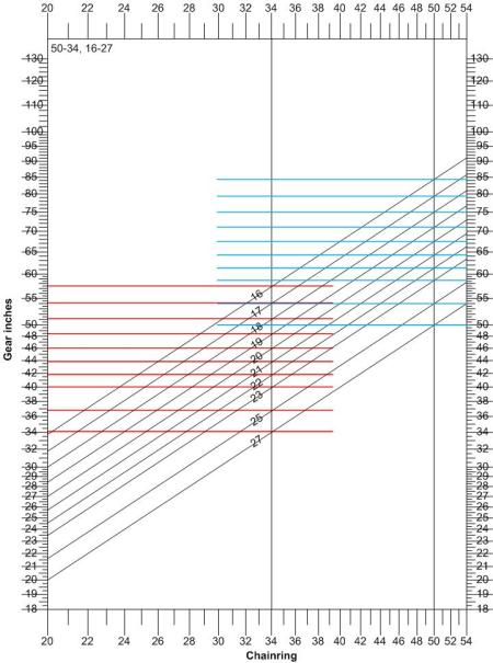
2008 10-speed 50-34, 16-27

Here’s how it looks, graphically. The red lines show the ratios available with the 34-tooth chainring; blue is the 50. Not a whole lot of overlap, and nice, fine spacing.

But… but… I do more than just commute to work, where the afternoon headwind is the hardest challenge. And it turns out that the current generation Shimano rear shifters only shift down by 2 ratios when I sweep the lever all the way across its range. For a flat cassette, that’s pretty unsatisfactory (the one on the Richard Sachs does 3, and that’s what I was expecting: boo, Shimano!).

The cassette that came with the bike was sitting on the shelf in the garage. Today, I swapped it out: 11-28, where the previous one was 16-27 (those are the number of teeth in the smallest and largest cogs, respectively).

Took it out for a ride (35 miles, 1200 feet of climb), and I think I’ll keep it. Observations:

  • The low end is just slightly lower, 28 teeth instead of 27. Lower is always welcome, so that’s fine.
  • The range on the small chainring (34) is as great as the range across both rings with the flat cassette. To do the same as before, I hardly need the 50-tooth ring at all. The small-small combination makes a little noise, so I don’t quite get easy use of all 10 ratios, but it’s close.
  • The 50-tooth chainring is pretty much wasted. Assuming a modest cadence of 95 rpm, I could push the high end ratio up to 35 mph. I might dream of needing that capability, but the fact is that it’s completely useless. Around here, grades steep enough for that speed are not straight enough. Maybe in the Rocky mountains, but I doubt it. On my check ride today, I did power a couple of downhills into the high 20s, 6 or 8 MPH faster than I could push the previous gearing. That’s enough.

So my next challenge is to see whether I can find a large chainring that will fit the Ultegra crankset. Looking at the graph below, going all the way from 50 down to 44 teeth would be okay, but anything smaller than 50 would be an improvement.

Trek1128

As before, the red ratios are for the 34-tooth chainring. Green is for the 50, and blue shows what a 44 would offer. Clearly, the high end of the green range is not useful.

(Soapbox: Most bikes, and most bikies, are geared too high. 53 teeth in front is not uncommon. As well as going slower than they could, there is a non-trivial risk of injury.)

We, who like to tinker, are always trying to optimize. Will this be the last round of optimization? Probably not, not until some clever manufacturer offers a semi-infinite range with semi-infinitesimal granularity.

Driver hall of shame: California 5FEK842

May 19, 2013

19 May 2013, 11:35 AM, Sand Hill Road, Menlo Park: light green Jag. She comes from a side street fast onto Sand Hill without even looking. Had I been a half second earlier on my bicycle, or less agile in swerving left (hoping there were no cars coming up behind me), she would have killed me. As best I could tell, she never knew I was there, even after the near miss.

Coming from church, maybe, feeling sanctimonious? Little does she know how much she has to be thankful for.

Bike to work day

May 9, 2013

I have been cycling to work more or less forever. Most times, I ride to Ericsson by road in the morning (14 miles, about) and go home by way of the shoreline trails (about 15 miles). To my mind, that’s a fairly long commute. I consider 15 miles about the outer limit of what’s feasible for a bicycle commute, for reasons of time, if nothing more.

I have consistently participated in the bike to work day, but have never come close to winning the longest-commute prize. Some guy always rides in from South San Francisco, a distance that Google maps puts at 38 miles. Clearly something he doesn’t do every day…

Well, if that’s how the game is played, I can play it, too. Got up at 4 this morning, out the door just a few minutes before 5 into a 50-degree overcast night. The radio said there was fog in the area, but not here. I wore a light long-sleeved shell over my cycling jersey, thinking I would take it off when the day turned sunny, but the day didn’t turn sunny, not until long after I was at work.

The old generation incandescent lights just would not have been enough, full stop. I have LED headlamps, one on the bike, another on my helmet, and the combination does pretty well. I could see well enough to avoid the broken pavement on the east approach road from the Dumbarton bridge, broken pavement that could easily have blown a tire.

Passed a dredge along the levees, lit up like a small casino. Do I stop for a photo? No, not today.

I met several cyclists going the other way; their headlights were blindingly bright, and I suppose mine blinded them as well. Good. By the time I got to the Ardenwood farm trail, the dawn was gray, and as I continued out Decoto road and reached the Alameda Creek trail, I switched my lights to flashing mode.

At Mission boulevard was a freight train, moving slowly into Niles Canyon. I rode beside it for a while, almost keeping pace with it, until it disappeared into a tunnel. By the time I had followed the road around the hill to the emergence of the rail tunnel, the train had picked up speed and disappeared.

Without motor vehicles, Niles Canyon would be a terrific bike route, easy grades through pretty country. With traffic, this is the stressful part of the ride, stretches of road, several bridges and undercrossings with narrow lanes and no shoulder. By the time we reach Sunol, the road is wider and there’s less traffic, and beyond I-680 on Calaveras road, it’s not a problem. Even though they are rebuilding the Calaveras dam, the on-road construction traffic was minimal, mostly just guys on their way to work. Not many; from their viewpoint, I am a latecomer.

The climb through the hills and around the lake is the only real work of the day. I would be happy to have one more low gear, but the bike is okay with what I have. Passed two other cyclists on the way up the hill, maybe doing the same thing as I am, cycling to work.

Pretty country still, but by the time I reached the steep drop into Milpitas, I was ready for a change. It was still another 10 miles, a different kind of riding, jamming through the morning’s traffic.

Just after 8, I checked in at the bike-to-work table in front of Ericsson, 47.88 miles (and 1860 feet of climb), only to learn that the guy who always commutes in from South San Francisco now works at Dell, presumably next door. There’s room at the top, as my colleague Mark said. I heard later that someone had ridden in 30 miles from Pleasanton, maybe also via Calaveras road, so had I just done the ordinary 14-mile ride, I still would have been far out of the running.

Well? Well? Did I win the longest commute award? Doubtless I’ll find out tomorrow.


Late-breaking news: Yes, I did. The 30-mile Pleasanton rider came in second. Woo-hoo!

First 100km ride on the new bike

November 11, 2012

Saturday, 10 November 2012

I had a few things to do today, so I didn’t go for an all-day outing. It was around noon when I went out wandering, hoping to find something interesting to photograph.

After a few minutes at the Elizabeth Gamble gardens, I meandered over to Stanford, which was having a football game. Crowds everywhere near the stadium, the eucalyptus forest a parking lot for the day (at $15!).

In the center of the academic areas was a crowd of young people, very dressed up, all wearing name tags. Maybe on a campus visit, hoping to attend Stanford next year? At Memorial church was the usual weekend collection of brides with their maids and their photographers.

Nice.

I went on over to the succulent garden, which is not as colourful at this season as at some other times, but still… not bad.

Notice (above) the nubs of two more flowers, one well visible at the lower right, the other just a point below the two red thorns.

Sunday, 11 November

Because of the Achilles trouble, I had not done a 100 km ride for several years. And my new bike has closer ratios, which means it won’t be as good on steep uphills. But… the Calaveras loop is a fairly easy 100k, less than 2 000 feet of climb.

It was about 36F on a cold, clear, beautiful morning when I bundled up in all my winter cycling gear and headed out. I have not ridden this route for so long that I thought I might have trouble remembering my way through Newark and Fremont — but the hindbrain (or something) remembers. Stopped at Ardenwood farm to shed the winter gloves, earband and outermost layer of jacket.

I think I might do better with electrolye replacement, rather than just water. On a recent hike, I took along a quart of Gatorade. Today I had a bottle of stuff from GNC. I discovered when I read the label that the GNC drink had only 5 calories! I had been thinking something like the 200 from the bottle of Gatorade.

I had only put about 200 calories worth of munchies in my rackpack. Fortunately, there is a mini-mart at Sunol junction, where I was able to tank up with a sweet roll and a package of peanuts. Much better.

I only needed to use the small chainring when the road started climbing as it passed the turnoff to Sunol regional park, and then it’s a steady grunt to the top, where I stopped for views of the Calaveras dam reconstruction.

The water level has been low for years, and I had always thought it was because of inadequate rains. The story turns out to be that the old dam was seismically unsafe. With the new dam, they will be able to store a lot more water in the lake.

I see the work in progress from the distance of the hills in Sunol park, but I haven’t been along here to see the details. Very quiet — I’m glad it’s not a weekday.

Big project.

I don’t  know a good way to take Calaveras through Milpitas, so I turned over to Yosemite Avenue, which gets across I-680 to Milpitas Boulevard, thence Montague Expressway to the Great Mall of the Bay Area (!), which gets me across I-880 and into the neighborhood of the Ericsson offices. I know my way home from there.

Stopped in Sunnyvale Baylands park to soak up the rest of my calories and much of the GNC funny water. 100k is not a particularly long or dramatic ride, but it’s nice to be able to do it. No ankle pain, just tired muscles.

The difference between men and boys…

September 30, 2012

… lies mostly in the price of their toys.

Saturday, 29 September 2012

Much as I hate to admit it, because the Richard Sachs bike is really nice, it just wasn’t quite what I needed. So instead of a long hike today, I dressed up in cycling clothes and rode to Redwood City.

I am also thinking of a new car, so I stopped at Redwood City Honda to see if a bike would fit into the back of a Honda Fit. They showed no interest in acknowledging my existence, so I went on. (I stopped at Anderson Honda in Palo Alto later on. Yes, a bike will fit into a Fit.)

At Redwood City Kia, I found that I could indeed fit the bike into the back of a Soul. I went back later and took the Soul for a test drive. It would not be a big surprise if I bought one, one of these days.

I went on to Carlsen Subaru, which had no Crosstreks in stock, but I’m told that it’s the same as an Impreza, and the bike fit into the back of an Impreza with no problems at all.

Well, this is all fine, but what I really intend today is to buy a new bike. I like Chain Reaction Bicycles, and Chain Reaction likes Treks. I won’t bore you with details that are of interest only to bikies, but the bottom line was that I bought a carbon fiber Domane 4.5. Nice.

I’m sure the white cork tape will turn gruddy within the first few rides, especially if I take the unpaved trail past Moffett. At some point, I will undoubtedly re-tape it black. But it sure looks nice, pristine and new!

Pretty classy, if I do say so myself!

Achilles surgery + 4 weeks

August 5, 2012

My ambition this weekend is to hike from the flatlands to Skyline, probably the short loop at Windy Hill: up Spring Ridge trail, down Hamm’s Gulch trail. I’ll do the hike Saturday; if it goes really well, I will also try a modest bike ride on Sunday.

The hike: only 7.2 miles, but 1500 vertical feet. From the parking lot at the bottom to the parking lot at the top is usually just a bit more than an hour, a bit less if I push it (but without running). This time it was about 1:15. Taking it easy, not risking injury.

Cold and windy up there; fog blowing hard across the ridgetop. If I had had a jacket, I would have worn it. No jacket, no problem. The downhill goes through the forest, and the trail was wetter than I would have expected for August. I guess the fog and the consequent condensation has been a fact of life up here this summer.

Stopped at Sausal pond, just before the parking lot on the way down. Nine people out of eight would probably have said there was nothing interesting here, certainly no animals around. Dave, of course, pokes around to see what might be lurking just out of sight.

Even the vegetable matter is not completely devoid of interest.

As to small animals, we first discover the empty husk of a dragonfly nymph.

But the real story here today is the proliferation of small frogs. They’re about 2 cm long, and shy. Dozens of them within three or four meters of my vantage point in the reeds at the shore.

And if reptiles aren’t enough, there are even a few unusual insects around.

When I got home, I filled a bucket with water, dumped in lots of ice and plunged both feet in. Yow! Fifteen minutes of that, and I’m happy. My first impression is that it went very well today. Will I change my tune when I wake up tomorrow morning?

Sunday morning: a little pain, but not bad. Let’s see whether I can do a bike ride.

The Portola Valley loop is less than 20 miles, less than 1000 feet of climb, and I can extend it if I feel good. If I take the physical therapist’s advice, I need to change many years of habit, and the way to do that is to put in the time, reminding myself constantly to adjust my pedaling stroke and riding position.

Felt good; I extended the ride to 35 miles, 1300 vertical feet, down Foothill expressway and back through the Baylands. Another fifteen minutes of ice water when I got home, just as a precaution, but I am very optimistic about progress. I don’t think I”m yet up for 20 mile hikes with 5000 feet of gain, but maybe it won’t be all that long.

Rancho San Antonio

June 28, 2010

Jacky and I went to a party in the afternoon, didn’t get out for hiking until 5 or so. Rancho is close by, so that’s where we went. It started when we saw a lone wild turkey coming across the meadow; as she got closer, we saw that she had two chicks with her.

Her course took her right past the corner of the tennis courts, surrounded by chain link fence, and with an open gate. Sure enough, one of the chicks got on the wrong side of the gate and was steered inexorably into the tennis courts. Sure enough, mom didn’t even notice.

I walked into the tennis courts, tried to work around behind Junior, with the idea of herding him back out the gate. But before I could get anywhere close, he had found a way to burrow under the fence. As we watched from outside, he actually flew, believe it or not, up toward the trees on the other side of the trail.

He had reason to fly: a hawk came soaring into the trees after him. The next thing we saw was Mom flying up out of the bush to defend her chick. We didn’t see Junior afterward, but there were no screams of death, so we hope he survived the adventure.

Already a good day from the point of view of seeing interesting things.

And then we saw a kingsnake, coming down out of the grass to cross the trail. When it saw us, it did a 180 and went back into the grass, but we approached in a slow and deliberate way, and it escaped the same way, so there was an opportunity for a photo or two.

Beautiful! You don’t see these guys very often.

And then further on, we found quail everywhere, also accompanied by their chicks.

The whole hike was only a bit over an hour, but we saw more than sometimes graces an entire day. A good thing to do.

Trying to improve bike path safety

January 3, 2010

An email exchange from summer of 2009. Surnames and email addresses deleted…

-----Original Message-----
From: Dave
Sent: Friday, June 12, 2009 5:29 PM
Subject: Website Inquiry

Comments: Now that the Moffett blvd bicycle overcrossing is nearing completion, I am concerned at what I see in the striping and fencing. It appears that those of us who come southwest on Moffett Blvd, wishing to turn onto northbound Stevens Creek trail, will have to make a 135 degree right turn into a single-wide gate to the trail. The potential for accidents is clear, particularly in the presence of children, wet weather, etc.

There is a perfectly good entrance a hundred feet further north, a 90 degree right turn onto a paved segment that joins up with the main trail. But the Moffett Blvd side is blocked by chain-link fence.

It would be good if these improvements at least did not make things worse for any of us. Please tell me you are going to keep the sensible entrance open.

Dave

From: Jack
Sent: Tuesday, June 16, 2009 9:34 AM
To: dave
Cc: Vroman, Mike; Macaraeg, Rodrigo; Fakhry, Sayed;
Kagiyama, Robert; Salvador, Angee; Wong, Wanda; Grimm, Louise
Subject: RE: Moffett blvd bicycle overcrossing

Dave,

My name is Jack and I am the city’s project engineer for the Stevens Creek Trail Overcrossing at Moffett Boulevard project.  The city appreciates your interest in our project, and I will try to respond to your concerns described below.

I have attached two photos of the northbound entrance to the trail taken prior to beginning construction.  As you can see, the fence and old remaining portion of the trail have been returned to the same configuration that existed before construction of the new overcrossing. In the past, riders going southbound on Moffett previously had to make a sharp turn onto the trail, the same as now.  Except for the time of the trail detour during construction, this trail entrance has not changed. The reason for the fence narrowing at the entrance is to help prevent users of the trail from inadvertently riding out into traffic.  There is a similar fence configuration on the southbound entrance to the trail at Moffett as well.

I agree with you that the paved vehicle entrance to the north of the trail entrance is a convenient access point for bicyclists.  However, this gate needs to be kept closed in order to prevent unauthorized vehicles from entering the trail.

For the reasons stated above, the city plans to keep the entrance to the trail at Moffett Boulevard the same as it is currently constructed.  We do suggest that, for safety, riders walk their bicycles as they enter the trail.  Please feel free to call or email me if you wish to further discuss this issue.  Thank you.

Jack
Senior Civil Engineer
(650) 903-6079

From: Dave
Sent: Tuesday, June 16, 2009 5:06 PM
To: Jack
Cc: Vroman, Mike; Macaraeg, Rodrigo; Fakhry, Sayed;
Kagiyama, Robert; Salvador, Angee; Wong, Wanda; Grimm, Louise
Subject: RE: Moffett blvd bicycle overcrossing

Thanks for the response, Jack.

Before construction began, my company was at Central and San Tomas in Santa Clara, so on my evening commute, I always came from Middlefield onto Easy street, past the school, through the parklet, onto the trail and straight across Moffett. I never had to make the right turn from Moffett onto the northbound trail. After the overpass project had begun, my company moved to the vicinity of north 1st and 237, so my commute now goes past Moffett park – I cross 101 at Ellis and come down the frontage road – and the right turn affects me every day.

I accept your word that the right turn was difficult and dangerous immediately before the project began, though I don’t remember it always being that bad. My recollection is that both lanes of the trail were once accessible, and only fairly recently – say a year before the overpass began – was the right side boarded off.  The pavement in the photos is evidence that t’was not ever thus.

Even in the days of my straight-through commute, the resulting narrow clearance made it difficult and dangerous to meet other trail users, especially since both directions are always focussed on the traffic light. It makes for some cursing when the northbound cyclist, going as fast as possible to stay within the light, meets a southbound rider or runner also trying to catch the light, and maybe at the same time someone comes down Moffett wanting to turn north/right, unable because of the tight turn to watch the cross traffic, endangering everyone. Rather than buying into the claim that it’s the same as before, I’d urge you to reconsider that aspect of the crossing as well, especially since the overpass will now collect most of the weekend casual users, and therefore the grade-level access will more often be used by experienced riders.

When you say the chainlink gate keeps unauthorized vehicles from entering the trail, I assume you’re talking about motor vehicles, not bicycles. It would be surely possible to gate that entrance in such a way that you couldn’t get a car through without unlocking a padlock and opening the gate, while leaving a gap in the fence wide enough for a bicycle. We have similar arrangements on most trails: gates that block bikes and/or horses during wet weather, but allow hikers to pass.

Dave

From: Jack
Sent: Thursday, June 18, 2009 4:10 PM
To: Dave
Cc: Vroman, Mike; Macaraeg, Rodrigo; Fakhry, Sayed;
Kagiyama, Robert; Salvador, Angee; Wong, Wanda; Grimm, Louise
Subject: RE: Moffett blvd bicycle overcrossing

Dave,

I didn’t want to leave you hanging. We have a couple of people looking into the issues you raise. We will respond to you next week.

Jack

From: Dave
Sent: Thursday, June 18, 2009 5:26 PM
To: Jack
Subject: RE: Moffett blvd bicycle overcrossing

Thanks, Jack. I appreciate the consideration.

Dave

From: Dave
Sent: Tuesday, June 30, 2009 4:46 PM
To: Jack
Subject: RE: Moffett blvd bicycle overcrossing

I was away on a business trip last week, Jack, and first commuted by bike today. I heartily approve the way you have resolved this issue. Thanks.

Dave

From: Jack
Sent: Monday, July 13, 2009 10:00 AM
To: Dave
Cc: Kagiyama, Robert; Macaraeg, Rodrigo
Subject: RE: Moffett blvd bicycle overcrossing

Glad we were able to resolve this issue for you.

Jack

From: Dave
Sent: Tuesday, August 11, 2009 7:04 AM
To: Vroman, Mike; Macaraeg, Rodrigo; Fakhry, Sayed;
Kagiyama, Robert; Salvador, Angee; Wong, Wanda; Grimm, Louise
Cc: Jack
Subject: Mountain View bicycle friendliness

A recent exchange with Jack resulted in improvements to the entrance from Moffett Blvd onto the northbound Stevens Creek bicycle trail, and much appreciated. Though not perfect, it’s good enough that I don’t expect to get hurt there.

But then the merge area between the street-level trail entrance and the overcrossing was turned into a dangerous three-way blind junction, where only yesterday I narrowly averted a collision with another cyclist. And if this was intended to protect the younger, inexperienced cyclists, I might mention that the rider I avoided at the last second was ten years old or thereabouts.

This merge was perfectly fine when I mistakenly thought the overcrossing project was completed. But then a forest of orange posts blocked off the safe route and steered all traffic into what is a blind junction from at least two directions. The sharp turn collects sand, which itself causes bicycle crashes. It just seems really perverse to actively create a hazard when none existed before.

It is probably not to be expected that the various people responsible for these facilities and projects are knowledgeable cyclists themselves. This leads me to the real point of the email: does Mountain View have a bicycle advisory group? If so, do they not provide input on this kind of issue, or is their input not accepted for some reason?

Turning to other bicycle-related topics, there are vehicle detectors that need to be adjusted, but there is no way to report them to the city of Mountain View. There should be.

The statements above are just bottom-line summaries, and it is fair to ask for explanation and justification for all of them. I am more than willing to explain or even better, demonstrate on a brief ride, the hows and whys of all these issues.

Although I live in Palo Alto, my daily commute goes through Mountain View, so I care. And unlike Palo Alto (imagine making Alma Street bicycle friendly), Mountain View could improve dramatically with little or no expenditure of money.

Dave

From: Jack
Sent: Thursday, August 13, 2009 3:21 PM
To: Dave
Cc: Vroman, Mike; Macaraeg, Rodrigo; Fakhry, Sayed;
Kagiyama, Robert; Kim, Helen; Jenkins, Joan
Subject: RE: Mountain View bicycle friendliness

Dave,

Thank you for your interest in bicycle issues in the city of Mountain View. We are very interested in getting the views of bicyclists like yourself.

On the recently constructed portion of Stevens Creek Trail, it is the city’s goal to try and eliminate high-speed merges. This is the reason that the old trail from Moffett Boulevard is directed to a tee intersection with the new through portion of the trail leading to the overcrossing. With this design, trail-users riding from Moffett Boulevard must slow down and/or stop and look both ways before proceeding on to the trail, similar to traffic on city streets. The orange delineators were installed to help slow riders to merge safely.

The plan to close the short section of the trail with the delinators was reviewed and approved by city park personnel and new trail overcrossing plans were reviewed by the city’s Bicycle/Pedestrian Advisory Committee (BPAC). If you are interested, the BPAC is usually scheduled to meet the last Wednesday evening of each month at city hall. Specific information regarding BPAC meetings and other relevant information for cyclists is available on the city web page. I hope this helps with your concerns.

Thank you.

Jack
Senior Civil Engineer
(650) 903-6079

From: Dave
Sent: Thursday, August 13, 2009 5:27 PM
To: Jack
Cc: Vroman, Mike; Macaraeg, Rodrigo; Fakhry, Sayed;
Kagiyama, Robert; Kim, Helen; Jenkins, Joan
Subject: RE: Mountain View bicycle friendliness

You could prevent high-speed merges by just removing about half of the orange posts. No blind intersections, and riders would have to slow down to go through the barricades. Far, far safer. (In a way, it’s too bad you don’t have a way to collect accident statistics on bikeways. No way to learn from bad experience.)

I guess the point about maladjusted vehicle detectors is just my tough luck.

Once upon a time, Mountain View installed a light at the intersection on Charleston where today you go into REI. I had the wonderful experience of meeting a MV traffic engineer who came to adjust the detectors and actually worked with me on my bike to verify that they were indeed adjusted properly. Once in a lifetime!

Dave

From: Dave
Sent: Friday, August 14, 2009 5:30 PM
To: Jack
Cc: Jenkins, Joan; Kim, Helen; Kagiyama, Robert;
Fakhry, Sayed; Macaraeg, Rodrigo; Vroman, Mike
Subject: RE: Mountain View bicycle friendliness

Great news, Jack – I solved my problem (and it was clear that it was just my problem).

Instead of dealing with the maladjusted detector from Leong onto Moffett Blvd and the hassles of the grade-level access to the Stevens Creek trail, I came along Whisman (where I met a wrong-way cyclist: no problem), through the Whisman School park (mother and toddler: no problem), and flew over the flyover. The no-high-speed-merge hazard isn’t blind from the flyover descent, no problem.

An extra quarter mile, but far safer. How much safer? Hard to quantify, but this route is one that won’t give me cold sweats when I wake up in the middle of the night.

Much better, and thanks for giving me the incentive to try something different.

Dave

Commentary

I thought it was especially interesting that, while we both claim to be concerned about safety, Jack’s version is from an abstract point of view, with zero regard for how real people will behave in real situations (imagine anyone stopping at a trail junction?). My version is based on experience with road rash, broken bones and expensive bike repairs.

We knew, of course, that you can’t fight city hall, but you have to keep trying. At a minimum, this exchange might prove useful someday if someone sues the city of Mountain View for negligence.