Archive for March, 2015

Morgan territory

March 29, 2015

Sunday, 29 March 2015

Kent and I have been trying to arrange a hike for years, and something has always come up at the last minute. But today, we’re really going to do it! I went to his house in Livermore at 1, having spent the morning attacking purple star thistle at Rancho San Antonio open space preserve.

P1170662

We hiked at Morgan Territory regional preserve. I’m not sure I’ve ever been here before, but it’s a beautiful place, especially at this time of year while everything is green. Open oak forest, mostly, with manzanita at one corner, and the poison oak fairly well contained: large and visible where it exists.

P1170620

Wildflowers everywhere. Most of them not very dramatic in themselves, but they add up to a nice show.

P1170623

P1170625

And a swallowtail, first one of the season, I believe.

P1170628

P1170631

P1170635

P1170639

The view off toward the east or southeast, the windmill farm not doing much right at the moment. Looking further north, we could see snow-capped Sierra, dimly, but unmistakably.

P1170646

P1170650

And my favorite, as you would predict: a wolf spider, and pretty good sized for this early in the season.

A good hike in good company, a great day.

Hiking in the rain

March 22, 2015

Sunday, 22 March 2015

Intimidated by heavy mountain bike use, steep grades, blind curves, I don’t visit El Corte de Madera open space preserve very often. Even when I was a mountain bikie myself, I didn’t come here, same reason, as well as the fact that it’s more technical than I’m really up for. But I haven’t been here for a while, and it was a rainy day, with fewer bikies than usual. Parked at the newly opened lot off Skyline and hiked the perimeter trails clockwise. A bit less than 16 miles, but 3800 vertical feet. I earned my beer.

Nice to hike in the rain and the coolth. Two or three times it stopped raining and I stowed my rain shell, and two or three times I dug it out again.

P1170577

Especially recalling the lost hikers I helped last September, I have long been unhappy with the state of the trail signs here. Today I decided to photograph the signs at all of the trail junctions on my route. I documented inconsistencies with the paper map, absent signs, erroneous signs, vandalized signs … (what else is there?). Needs a clean-up.

For broom too large to take by hand or with a small weed wrench, I now have a small folding saw – I can at least girdle them. I added the saw to my hiking kit, and found several uses for it today, clearing the trail of debris that would otherwise have required a trail report.

P1170615

This year’s new growth is a lighter, brighter green than the old foliage. Makes the trees look as if they’re decorated.

Broom at Bear Creek

March 21, 2015

Saturday, 21 March 2015

Another open space volunteer event. Today’s was in Bear Creek redwoods open space preserve, the area west of Bear Creek road that isn’t open, even by permit. It was a fairly large group and we made a serious dent in a non-trivial area of broom, though there is enough for any number of additional days in the future, should we like.

Mostly redwoods, and very pretty. After a morning of work, the lunch break was in a cool and pleasant redwood grove. Not far away, a single broom plant stood a foot high in a tiny patch of sunlight, highlighted by the ubiquitous god Taunt. After a few minutes of increasing irritation by all of us, Paul got up, walked over and uprooted the thing.

After lunch, we took a short hike to see a couple of the really old-growth redwoods.

P1170565

Ellen, shooting a picture up the tree. It’s hard to appreciate how big these are without something of known size as a reference, for example a person.

P1170559

What Ellen sees up there.

P1170557

This same tree is very interesting inasmuch as it has an off ramp around on the back, and toward the end of the off ramp, another tree springs forth, goodly sized in its own right.

P1170561.

Not only that, but the next tree over has much the same arrangement. I have no idea why this happened. Ellen thinks they are genetic duplicates, siblings sprouted from a long-lost parent, but I have trouble thinking that this is a natural growth pattern, regardless of DNA mutations.

I remarked to a friend that it’s a good weekend when I don’t show symptoms of poison oak on Monday. We’ll see!

New Nicholas trail at Sanborn

March 15, 2015

Sunday, the Ides of March 2015

I haven’t been to Sanborn county park for several years. It’s a bit out of the way, and pretty much out and back. But there is a segment of trail that I have never visited, the John Nicholas trail, isolated off in the southeast corner of the park. They have now built a 3.4 mile connector from Skyline, part of the Bay Area Ridge Trail system. The grand opening is in a couple weeks, but not being one for ceremonies and crowds, I thought I’d check it out today.

It takes a couple hours to grunt to the top of Sunnyvale mountain, where the new trail begins. Cool and pleasant, several newts out on the trail, Todd creek redwoods pretty, and some water running in Todd creek. All is right with the world.

P1170556

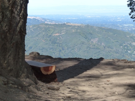
The new trail is heavily switched back and wide, the forest is open. The first thing of note was this schöne Aussicht, where I decided not to embarrass myself trying to speak German with the three German mountain bikies there.

P1170549

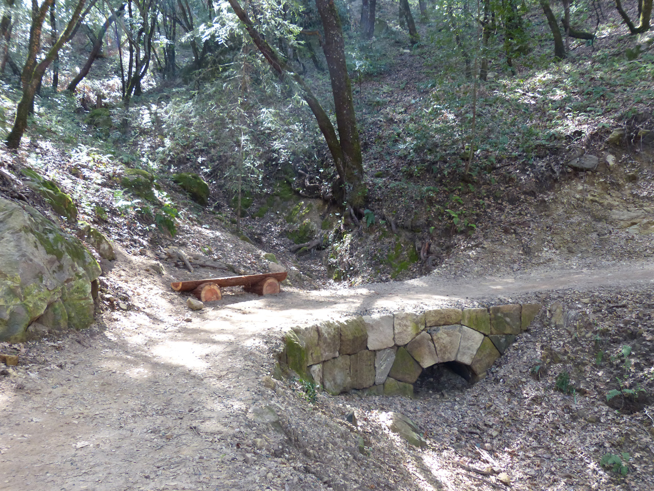
The upper reaches of the trail go past some of the rock that also contributes to Castle Rock state park on the other side of the ridge. Split redwood logs form benches here and there.

P1170555

The letterbox formations are called tafoni. We think of rock as gray, but there is a lot of color here (compare below, B&W by Photoshop).

P1170555

P1170553

Mountain bikies everywhere. The trail is wide enough that there are few hassles. It is also the best graded trail I have ever seen, almost a constant 6.6% grade (according to Excel based on the topo map), not steep enough to really go crazy downhill, not steep enough to die going uphill.

P1170537

At the bottom is a dam and Lake Ranch Reservoir, of which I had never heard. And yes, that’s broom. Really nice to see broom and think, “Not my problem!”

P1170544

The water level is well below the fill mark and we see dried mineral deposits from previous years.

P1170542

John Nicholas trail – the old part – continues for another 2 miles. An amazing chunk of rock here.

The previous trail ends at Black road, a side road that I believe I have never taken. I was surprised to see what is actually a pretty good road; it’s even wide enough for a yellow line down the center.

I returned to the dam, and took the Lake Ranch road trail down to Sanborn road. It’s out and back, of no particular interest, but I may never be here again, so now is the time. It’s only 0.6 miles, but it turns out to have an average grade of almost 18%, almost 400 feet of descent, very steep. And of course returning from the bottom, grunting back up. The old map says there is no parking there, but there is in fact roadside parking and there were half a dozen cars.

Speaking of which, these trails really are pretty popular, and not just with the mountain bikies. Not jam-packed, but certainly not deserted, especially along the flat around the reservoir. Met several groups twice and one group three times, as we did our outs and backs.

P1170546

Well, I could have walked about 3/4 mile on Sanborn road and been back at the park entrance, but of course that would never do. Back up the hill, along Skyline ridge, and down by way of the trail (19.4 miles for the day, 3850 vertical feet).

P1170548

I am impressed with this trail; it’s wonderful. But I can’t help thinking that if the trail designer had been spending his own money, or even a foundation grant (John Nicholas foundation maybe?), rather than unaccountable taxpayer funds, likely funneled through Washington, he could have made some more economical choices.

Springy day

March 8, 2015

Sunday, 8 March 2015

After almost seven hours attacking broom at Purisima yesterday, I wasn’t sure I would be up for a killer hike today. So I parked at Palo Alto Foothills park and hiked up the hill and around a loop comprising Los Trancos open space preserve, Montebello, Coal Creek, Russian Ridge, Skyline Ridge and back through Montebello and Los Trancos. Turned out to be 19.7 miles, killer distance, but only 3500 vertical feet.

The adventures began as I parked the car: two deer browsing in the woods just above the parking area. I crossed the hill and down into Wild Horse valley, where I found a bull turkey showing off. Jacky says it should be called a Tom, but she didn’t see how big it was !

P1170400

P1170445

Do you suppose he knows how delicious he looks?

P1170418

“Just ignore him, Margaret, he’ll go away.”

P1170439

None of us males really looks that great from directly to the rear!

P1160849

At Los Trancos, I was happy to see that the bridge whose pending destruction I had flagged in January (above) has been rescued (below).

P1170458

P1170459

Not quite so happy to see that a downed tree I had also reported in January is still there. I’ll report it again.

The wildflowers are out in profusion. Very nice.

P1170457

P1170462

P1170508

Near the bottom of Meadow trail in Coal Creek OSP, I saw what I think was a mountain lion. Only a second, and I didn’t get a good luck, but it was dark, bigger than a deer or a coyote or a bobcat, low to the ground, and running, rather than bounding along the way deer do. The only other possibility I can think of is a wild pig, but a) I have never seen one on the peninsula, b) it was making less noise than I would expect from a wild pig, and c) at this time of year, it probably wouldn’t have been alone.

P1170476

Russian Ridge, Mindego hill to the left, fog over the ocean. Very nice.

Insects are beginning to feed on the California poppy blossoms. I looked for yellow or orange spiders lurking to feed on the insects, but didn’t see any. Well, it is early in the season yet. They’ll be around shortly.

 P1170470

P1170477

P1170480

P1170487

I was reading a book set in Sweden recently, in which the protagonist watches carefully for the first butterfly of spring. The species was an omen of good or ill fortune. No chance here! I saw practically every kind of butterfly we ever have, even including a swallowtail. Impressive.

Also found an empty cicada shell on a blade of grass.

P1170496

Confirmed wildlife sighting: a gopher, Russian Ridge. Not as exciting as a mountain lion, but I take what I can get.

P1170514

P1170524

P1170522

This wildlife camera is at the top of Los Trancos trail in Foothills park. I suppose it took a picture of my mid-section.

I found a big blossomy broom near here, stopped at the gate when I got back to the car to tell the ranger about it. Don’t know whether they’ll do anything, but it doesn’t hurt to let them know.

Quite a day for mini-adventures. Great to be out, even if my feet are sore.

Crisp

March 1, 2015

Sunday, 1 March 2015

I have been bothered for a long time about broom along the North Ridge trail at Purisima Redwoods open space preserve, so today I did something about it (5.6 hours). Hard work, but I made a visible difference.

P1170373

Yesterday’s drizzle cleared the air completely, along with some overnight rain. The view from the trail, with the radar dome at Princeton visible at the far right (part of SFO’s traffic control).

P1170371

From a little further along, the head at Princeton, the harbor breakwater visible, with the surf of Mavericks extending to its left. The town of Half Moon Bay is partly visible at the near left.

P1170375

But I think what impressed me more than these nice crispy views of Half Moon Bay was the fact that the Farallons were visible, a cluster of small uninhabited islands about 30 miles off the Golden Gate. I don’t think I have ever seen them from here; truly an exceptionally clear day. According to Google Maps, the nearest of these islands is almost exactly 40 miles from me, as the photon flies.