Posts Tagged ‘Scottsbluff’

Scottsbluff, again

July 23, 2016

Saturday 23 July 2016

IMG_2940

There is a second museum here, the Farm and Ranch museum, FARM, so we stopped to see what there was to see. Much is under construction, not really advisable for unrestricted public access, but a pleasant young woman was kind enough to show us around.

IMG_2945

The first attraction is a house, donated by a local family and restored to authenticity as certified by the family itself. Not completely antique; the phone has a dial.

IMG_2946

Notice the heat exchanger atop the refrigerator. The range was electric, with coiled heater wires exposed in the grooves of the burners.

IMG_2947

IMG_2953

Outdoors, the first attraction is a jail cell, manufactured by a company in Detroit and available to those who might have need for such a thing. We presume it would normally be installed indoors somewhere.

IMG_2948

One of the larger of many tractors. The ambition is to restore as many machines as possible to working order, but it is a self-funded volunteer effort, so it’s completely open-ended.

IMG_2956

Not even sure what some of these things are.

IMG_2962

This one is a combine, actually never used, but donated by the manufacturer to the museum.

IMG_2965

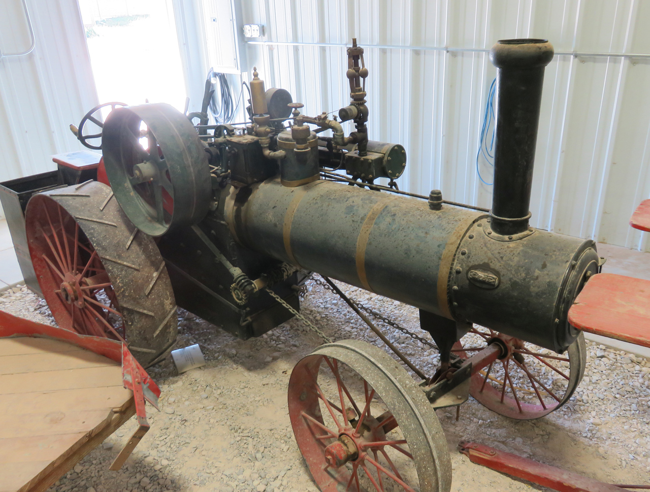
There’s a big equipment shed, whose star attraction is arguably this big steam tractor. Our guide wasn’t sure this one would be possible to restore.

IMG_2966

The hearse is sometimes rented out, and not just for movies. Supply your own horses and enjoy a stylish final trip.

IMG_2968

IMG_2979

A kit tractor made by Ford, parts from model T or model A, our guide wasn’t sure which.

IMG_2982

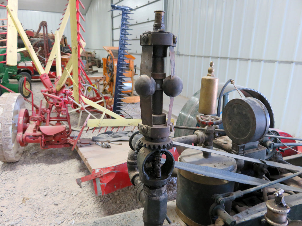
A smaller steam tractor, with some of its gubbins, below.

IMG_2983

IMG_2986

IMG_2989

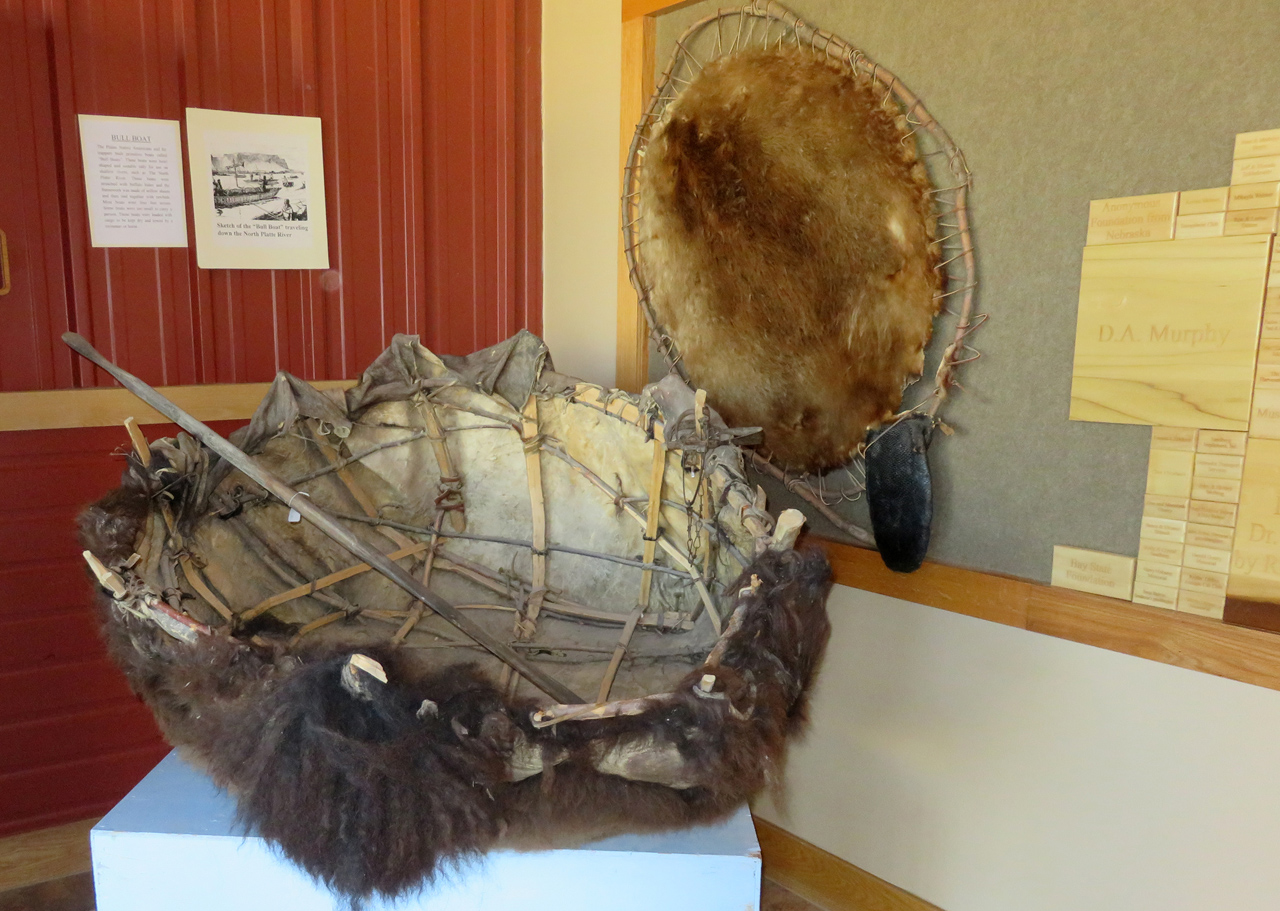
This is a bullboat, a buffalo hide stretched over a frame. Big enough for one trapper and his load or furs, or a smaller version big enough for the man and his gear but not a load of furs.

We went to Dorthey’s for lunch, but we supplied the lunch. We get far too few veggies on these trips, so we stopped at the grocery store and bought a package of broccoli slaw, some blackberries, and in a concession to the inevitable, fried chicken.

Then off to a tour of the new high school, under construction. They had only enough hard hats for half of those who signed up, and we were in the group that toured the existing high school under the guidance of the principal. My reaction was great relief that I will never again (I fervently hope) be associated with such a place. We bailed out after the first part and never did see the new construction.

After saying good-bye to Dorthey, we stopped at a liquor store for some porter, a couple of bottles of which we enjoyed on the balcony of the B&B. This evening, the formal reunion dinner at the Country Club, and tomorrow back on the road.

Scottsbluff

July 22, 2016

Friday 22 July 2016

Up at 5, out to the monument for a beautiful sunrise. We hiked all of the trails that were open from below and got back to the B&B in time for breakfast at 8.

IMG_2814

IMG_2830

IMG_2846

After breakfast, we stopped again at the monument, went through the visitor center and drove to the top. Very impressive 3D model of the terrain. The entire ridge was originally called Scotts Bluff, but the term now pertains only to the rock beyond Mitchell Pass, above the gap in the photo.

IMG_2915

In answer to my question: why did the pioneers come over the pass instead of going around the end, the answer is the extensive badlands below the bluff (the service road was built much later), and the quicksand further down into the North Platte flood plain.

IMG_2867

As to the rockslide that closed the trail, here it is. The signs warn about the upper surface having been undercut, so there could well be more risk than just loose rock fallen across the trail. We were able to hike only to a point on the near side roughly below where I stood to take the picture.

IMG_2919

I dropped Jacky off at Dorthey’s and went out to explore a little. High 90s again, so I’m not too ambitious, but then there’s not a lot to do around here anyway. Walked the main street of Scottsbluff, enjoying the uses to which the old theater has been put.

Jacky is completely down on Runzas, refuses to eat at Runza restaurants. So I tried one for lunch, just to form an independent judgement. It was okay, but we do a far better hamburger and cabbage pie ourselves at home. Not least because we would use red cabbage.

IMG_2926

Went to Lake Minatare, which has a lighthouse. No idea why. Tight spiral staircase to the top, where there is a view that’s pretty much the same as at the bottom. But it was something different to do.

Found a spot under an awning to read my book until the afternoon thunderstorm blew up. Rained pretty hard while I was in the car looking for trees to get under in case of hail. There were reports of big hail in the area, but none where I was. That’s fine with me.

IMG_2933

Back to Gering to pick up Jacky, and we went out to the reunion picnic, well out of town, but at a very nice meadow with a pretty pond.

IMG_2939

Of course, I didn’t know anyone, but several of the significant others banded together and talked about topics unrelated to the good old days. Probably upward of a hundred people, bluegrass band (without excessive amplification!), the usual picnic fare, and a good time was had by all.

Gering

July 21, 2016

Thursday, 21 July 2016

We did nothing much today, visited Dorthey, spent most of the afternoon in the air-conditioned library, took Dorthey to dinner at a godawful good-ole-boy restaurant that was just what she wanted. And escaped with our three remaining bottles of oatmeal porter to the deck on the back of the Barn Anew B&B, looking out at Mitchell Pass.

IMG_2742

While sitting there spoiled, what should my wondering eye behold but a fox. Don’t see many of those, at least not where we live! Cool!

IMG_2753

After doing our duty to the beer, we wandered the grounds of the B&B. We are the only guests tonight, as it happens.

IMG_2759

They have about four sheep wagons, at least two of which appear to have been fixed up such that they could be used for overflow guests. No plumbing, I suspect, so likely just a place to sleep.

IMG_2766

IMG_2763

And the head of a windmill. We don’t see those close-up very often.

IMG_2769

I think I mentioned that the B&B had been reconstructed from a barn. There was also a house that was in pretty bad shape. The house itself was demolished, except that its bay window has been turned around and now forms the backdrop for the weddings that are performed here. Nice.

IMG_2772

This the the old barn itself. We sat on the porch and watched the sunset.

IMG_2774

IMG_2791

The sprinklers were busy keeping the wedding venue green, and the spray in the sunset light was purely fortuitous.

IMG_2796

One of several cats came around to make friends, but when we didn’t pet it, it decided that a nap was the better part of valor. Agreed. Good night.

Making our way through the wilderness

July 21, 2016

Wednesday, 20 July 2016

Up early and out of our BnB (no breakfast: just a B, I guess) in Spearfish.

IMG_2321

Drove to Deadwood where we parked curbside, hoping to eat before the parking meter enforcement began. No problem. Pricey breakfast in Bullies hotel and casino, and we headed on south on the scenic route.

IMG_2334

Next stop was two or three points around Pactola reservoir, surrounded by pine forest, with a few boaters already out on the water. Pleasant place.

IMG_2352

Then a quick stop at Hill City to enjoy the trains. Big crowd already lined up waiting for the train ride in an hour. We don’t see any point in that kind of thing, but it’s fun to wander around and look at the  big machines.

IMG_2362

IMG_2368

IMG_2374

IMG_2382

Further south, the map showed Cascade Spring and Falls as notable roadside stops. We didn’t stay long at the spring; signs warned of poison ivy right at the picnic area and more down along the water, and we believed them. Not the kind of adventure we need today.

IMG_2387

IMG_2430

But we stopped longer at the Fall, a distinctly optimistic description of a few vertical feet of rapids. Pretty place.

IMG_2425

I like to view the texture in fast-flowing water by setting the shortest exposure possible.

IMG_2438

A family was there, also enjoying the water.

IMG_2443

IMG_2448

Much of the Black Hills region is quite pretty, but as we got further south and into Nebraska, we got more into the long stretches of rolling grassland that don’t have much to offer. Stopped briefly in Crawford, where we talked with an Information volunteer for a few minutes, and then we went on to Fort Robinson.

IMG_2463

The fort is back into the pretty country, probably as much because of water as anything else. Cavalry and infantry, late 19th century. Brick buildings, many of them, some adobe, some wood-frame. Big (big!) stables, as would be expected for a cavalry base.

IMG_2512

And stagecoach rides. The employee hitched up the team while we watched, and drove the coach out. The girl got to sit up top with him, and on the way back, she got to drive.

And then, more long miles in the hot, until we reached Agate Fossil Beds national monument.

IMG_2544

IMG_2593

Above the visitor center is a trail to a couple of the hills where the big finds originated. We hiked up in hundred-degree heat, glad that it crossed the green of the Niobrara river flood plain, and that the total loop was only a couple of miles.

IMG_2602

When seeing the name, I have always wondered why agate geology and fossils were compatible. Turns out they are not, of course. The ranch was called Agate Springs ranch because of what’s called moss agate found in the springs here, and the spring got lost from the subsequent name. No quartz around here anywhere.

IMG_2657

Gazillions of insects along the trail, mostly grasshoppers, but also those who are happy to prey on grasshoppers.

IMG_2664

Even grasshoppers can be interesting sometimes.

IMG_2673

IMG_2682

IMG_2716

I think this little guy is a robber fly.

Getting on in the afternoon, and we need to find our BnB in Scottsbluff.

IMG_2725

Scott’s Bluff is the left end of this ridge, and Mitchell Pass is the low point between. Why, we ask, did the pioneers not just go around the end of the ridge, rather than climbing the pass? Good question. Apparently the badlands and muddy terrain along the North Platte flood plain were more difficult than the pass. (But Google Earth shows that the railroad builders went level along the river instead of winding back and forth up the grade.)

Our B&B is the Barn Anew, an old horse barn (percherons: big rooms on the ground floor!) that has been rebuilt for lodging. We’re told that the framing is original, but I imagine that the rest of it was reconstructed. Picturesque.

Into Gering for an evening with Dorthey, another long day, happy to be out of the car.

Mid country

July 2, 2013

Sunday, 30 June 2013, to Scottsbluff

We flew into Denver, rented an incredibly expensive Alamo car, met Maggie and her kids for lunch at a stop off I-25, and drove to Gering, where Dorthey lives. Dorthey’s 90th birthday is coming up, so it’s an excuse to visit the midwest.

P1030606

We stopped at Pine Bluff, Wyoming for tourist bumpf and a quick look at the archaeological site (a midden, which is a sophisticated term for a dump).

P1030799

Looking for interesting things to photograph, as always, for example the fine detail in this milkweed seed puff.

P1030679

In Gering (the German word for insignificant: it’s not accidental that there are a lot of German settlers in the history of this part of the country), we sat outdoors and enjoyed a cool evening and looked for small animals.

P1030695

Monday, 1 July, Gering

Jacky and I were up early, went out for a bit of a walk. The photo shows how much nothing there is around here.

P1030759

Just around the corner from Dorthey’s is a place with some distinctive junk sculpture in the yard.

P1030757

P1030777

We had a bit of breakfast, then headed out to the Bluff, as it’s known locally; that would be Scott’s Bluff. Hiram Scott died somewhere near here, although I don’t really know the story. Something about having been abandoned by his buddies, maybe injured or … ?

P1030985

I claim the photo above is the classic view, but Jacky thinks it’s just the National Park brochure view, nothing to do with the real one. That rock actually is not Scott’s Bluff, just another one of several buttes in the area. The Oregon trail runs below the butte here.

P1030856

We took the Saddle Rock trail to the top, so-called because the formation to the right can be interpreted as a saddle. Jacky thinks it looks more like a camel.

P1030863

The rock is a layered structure of mudstone and ash from an eruption of the Yellowstone caldera in geologically recent history. Considering that we’re maybe a thousand km from Yellowstone, we hope it doesn’t do a repeat performance anytime soon.

P1030865

P1030916

P1030872

P1030884

P1030907

Naturally, we keep an eye out for small animals, and find a few.

 P1030954

I especially like the way this little guy (above) is covered with pollen.

P1030995

Back at Dorthey’s, we took it easy; the day clouded over and rained for a while, then the sun came out, and we got a double rainbow. Very unusual, at least where we come from.

P1040199 P1040316

Even more unusual, the rainbow actually came all the way down to the ground. Cool!

Everyone, including Maggie’s kids, was shooting off fireworks, so that was the evening’s entertainment. No pro show, but then it’s not yet the fourth.